|
||

|

|
|

|
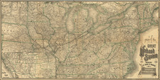
Rare two sheet map of the Theater of the French & Indian War. Little has been written about this map, much of it incorrect. While Kershaw and others have described it as a German edition Mitchell's map, the cartography is clearly based upon D'Anville's map of North America from 1746. First, the shape of the Great Lakes is clearly based upon D'Anville and bears on resemblence to the classical Mitchell treatment of Lake Michigan and Lake Erie. Second, as noted by Lloyd Brown in Early Maps of the Ohio Valley, the treatment of the Ohio Valley would seem to predate the Mitchell and Evans maps. Lloyd calls the map one of the earliest attempts to indicate the topography of the Ohio Valley and the surrounding country, as well as the dense forests and mountain ranges. Lloyd also remarks the use of fine shading and hachures to indicate relief is unusual for the period, and very effective regardless of the accuracy of the map. The projection on which it is drawn accounts for the distortions of shapes and distances. The language of the map is an interesting combination of Latin, German and English, with a few local Indian names included as well. Brown, who clearly studied the map much more closely than Kershaw, does not suggest a Mitchell tie in. There is no mention in any source that two states of the map exist, one with Fort Frederic (Crown Point) in an inset, one without. In all, a fine copy of a truly rare and interesting map. Brown 23, Sellers & Van Ee 59, Kershaw II:38, McCorckle 755.34.
![[Uncut promotional broadsides for ] Map of the Surface-Feeding Ducks, Swans and Geese of North America](https://storage.googleapis.com/raremaps/img/small/92052.jpg)
![Colton's United States of America [State of Colona named]](https://storage.googleapis.com/raremaps/img/small/90086.jpg)