|
||

|

|
|

|
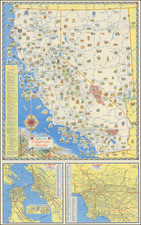
Highly detailed map of California, colored by counties, with insets of the Yosemite Valley, San Francisco and SF Bay Vicinity. While Gray's atlas began appearing in 1873, this unique set of insets only began appearing in the mid 1880s, at the very tail end of Gray's publication of his National Atlas, and are therefore quite scarce on the market. The inset of Yosemite and the inset of San Francisco are the earliest large format appearances of each region in a Commercial Atlas. The inset of Yosemite is especially interesting, showing the Coulterville Trail, Mariposa Trail and several other trails through the Valley and on the upper walls, and numberous rivers, falls, elevations and small encampments. The inset of San Francisco shows streets, parks, wharfs, rail lines and other early features. The state survey of California is nearly complete. Orange, Imperial and Riverside Counties are still not present. The primary map of California is one of the most detailed of the period and includes early topographical details. A nice example of this increasingly rare state of Gray's map of California. Single page maps of Nevada on the verso (with inset of Tahoe and Carson area) and Oregon & Washington.
O. W. Gray was a publishing firm based in Philadelphia. Later, they published as O. W. Gray & Son. They published atlases in the late nineteenth century. Gray's National Atlas was one of the most successful commercial ventures of the 1870s and one of the last to employ hand coloring on maps.