|
||

|

|
|

|
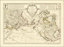
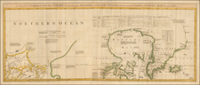
Important and highly detailed large format map of the NW Coast of America, but extending to Baffin Bay, Hudson Bay, and the confluence of the Mississippi River with the Missouri and Ohio Rivers. While the map's primary focus is on the Russian Discoveries in Alaska and the NW Coast, based upon Berhing, Chirikov, and De L'Isle, the map is of great interest for its treatment of the course of the Mississippi River Valley a well. Bellin's map is based upon Buache's Nouvelle cart des decourvertes, issued in 1758. The map extends indefinitely to the north and notes that the mythical voyage of De Fonte. The tracks of the voyages of Vaisseaux, Chirikov and Berhing are noted. Often overlooked is the wonderful treatment of the Mississippi River, which is shown extending to Lac Rouge, then to Lac Ouinpique (Winnipeg) and Lac Bourbon, then continuing to Hudson Bay, making for an uninterrupted water route from Hudson Bay to the Gulf of Mexico. A similar water course from Lac Oinipique to Lake Superior is suggested, although more tentatively so. The course of the Missouri and Ohio Rivers are well illustrated, although the source of the Missouri is unknown. Two rivers flow speculatively from the San Francisco and Puget Sound areas, seaching vainly and mythically for water course to the Mississippi. Bellin's map must be regarded as one of the most overlooked Transmississippi West maps of the period, incorporating the information from his seminal 1755 map of North America. Wagner 610.
Jacques-Nicolas Bellin (1703-1772) was among the most important mapmakers of the eighteenth century. In 1721, at only the age of 18, he was appointed Hydrographer to the French Navy. In August 1741, he became the first Ingénieur de la Marine of the Dépôt des cartes et plans de la Marine (the French Hydrographic Office) and was named Official Hydrographer of the French King.
During his term as Official Hydrographer, the Dépôt was the one of the most active centers for the production of sea charts and maps in Europe. Their output included a folio-format sea atlas of France, the Neptune Francois. He also produced a number of sea atlases of the world, including the Atlas Maritime and the Hydrographie Francaise. These gained fame and distinction all over Europe and were republished throughout the eighteenth and even in the nineteenth century.
Bellin also produced smaller format maps such as the 1764 Petit Atlas Maritime, containing 580 finely-detailed charts. He also contributed a number of maps for the 15-volume Histoire Generale des Voyages of Antoine François Prévost.
Bellin set a very high standard of workmanship and accuracy, cementing France's leading role in European cartography and geography during this period. Many of his maps were copied by other mapmakers across the continent.