


|
||

|

|
|

|
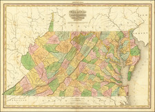
A good example of the first edition of Tanner's Map of Virginia, Maryland and Delaware, from Tanner's monumental New American Atlas, without question the finest of all 19th Century American commerial atlases. The issuance of this atlas represented a landmark in American cartographic publishing history, marking the first time a large format American published atlas employed the engraving quality of its European competitors. Tanner conceived the atlas as the first large format systematic mapping of the US and began the project with a prospectus issued in 1818 and therafter and began issuing the maps in subscription format in folio groups beginning in 1819. The completed atlas in bound form was issued for the first time in 1823, and is perhaps the most sought after of all American Atlases. Separate maps from this atlas rarely appear on the market. The present example has a bit of glue staining to the centerfold and a repaired split at the centerfold and ome minor soiling primarily in the margins. Several minor printer's creases top and bottom enter the image. In fine condition, this map now sells for about $2000.00. An essential map for collectors of this region.
![Map of the States of North & South Carolina [Large Charleston Inset]](https://storage.googleapis.com/raremaps/img/small/91846.jpg)