The item illustrated and described below is sold, but we
have another example in stock. To view the example which
is currently being offered for sale, click the
"View Details" button below.


|
||

|

|
|

|
Stock# 0843
Description
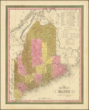
Nice example of Tanner's map of Maine, hand colored by counties, and showing towns, roads with distances, railroads, and a host of other details.
The key shows counties and towns, with populations, and populations on a decade by decade basis since 1765. Primitive early northern counties are still incomplete. Tanner's maps rarely appears on the market. A nice wide margined example.
![[Right sheet only of: A New Chart of America Florida to New York with the Principal Harbours on a Large Scale, Drawn from the latest Authorities, by Robt Blachford. 1807.]](https://storage.googleapis.com/raremaps/img/small/55819.jpg)
![[ Bunker Hill ] A Plan of the Action at Bunkers Hill on the 17th of June 1775 between His Majesty's Troops, Under the Command of Major General Howe, and the American Forces . . .](https://storage.googleapis.com/raremaps/img/small/70223.jpg)