This item has been sold, but you can enter your email address to be notified if another example becomes available.


|
||

|

|
|

|
Stock# 0815
Description
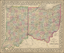
Nice example of Tanner's map of Indiana, with interesting early/primitive counties, Indian Lands, etc. The upper portion of the state is demarcated with an Indian Boundary and the Putawatomies and Miamis lands, but La Porte, St. Joseph, Elkart and La Grange Counties now appear. A number of steam routes, canals, proposed railroads and other features are prominently shown, along with towns, counties, etc. Profile of the Wabash Canal and list of steamboat routes from Louisville to Pittsburg and Louisville to New Orleans are shown. Tanner's New Universal Atlas became the standard work in the Industry until Tanner sold the rights to the atlas in 1846 to SA Mitchell.
![[ Middle British Colonies Map ] Pensilvania Maryland and Virginia](https://storage.googleapis.com/raremaps/img/small/98228.jpg)