


|
||

|

|
|

|
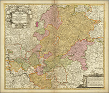
Detailed map of the region bounded by Maintz, Wertheim, Schweinfurt, Mulahusen, Gottingen, Cassel, Waldeck, and Coblenz, and centered on Landgraviatus. Two large title cartouches and approximately 20 coats of arms of the various principalities, etc. Long fold split in the map (about 2/3rds of the image) has been held together by the binding tab and tape repair on verso, else a nice example.
Johann Baptist Homann (1663-1724) was a mapmaker who founded the famous Homann Heirs publishing company. He lived his entire life in Bavaria, particularly in Nuremberg. Initially, Johann trained to become a priest before converting to Protestantism and working as a notary.
In 1702, Johann founded a publishing house that specialized in engravings. The firm flourished, becoming the leading map publisher in Germany and an important entity in the European map market. In 1715, Johann was named Imperial Geographer to the Holy Roman Empire by Charles VI and made a member of the Prussian Academy of Sciences. Most importantly for his business, his reputation and contacts gained him imperial printing privileges which protected his publications and recommended him to customers. Johann is best known for this Grosser Atlas ueber die ganze Welt, or the Grand Atlas of the World, published in 1716.
After Johann died in 1724, the business passed to his son, Christoph (1703-1730). Upon Christoph’s early death, the company passed to subsequent heirs, with the name of the company changing to Homann Erben, or Homann Heirs. The firm continued in business until 1848.
![(First World War - German Propaganda) Die Eisenbahn, der Lebensnerv des Heeres. [The railway, the lifeblood of the army.]](https://storage.googleapis.com/raremaps/img/small/89362.jpg)
![Pomeraniae, Wandalicae Regionis Typ [with] Livoniae Nova Descriptio [with] Ducatus Oswieczensis, et Zatoriensis, Descriptio](https://storage.googleapis.com/raremaps/img/small/61683.jpg)