|
||

|

|
|

|
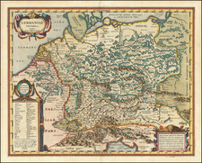
Highly detailed regional map of Westphalia, centered on Arensberg and Brion. The map is bounded by Lippstatt and Geseke and Paderborn in the North, Volckmarsen and Waldeck in the East, Bilstein & Waldenberg in the South and Balve and Menden in the West. Compass Rose and three cartouches, one with 3 coats of arms.
Matthäus Seutter (1678-1757) was a prominent German mapmaker in the mid-eighteenth century. Initially apprenticed to a brewer, he trained as an engraver under Johann Baptist Homann in Nuremburg before setting up shop in his native Augsburg. In 1727 he was granted the title Imperial Geographer. His most famous work is Atlas Novus Sive Tabulae Geographicae, published in two volumes ca. 1730, although the majority of his maps are based on earlier work by other cartographers like the Homanns, Delisles, and de Fer.
Alternative spellings: Matthias Seutter, Mathaus Seutter, Matthaeus Seutter, Mattheus Seutter