|
||

|

|
|

|
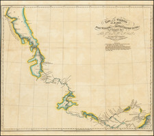
The earliest English language map to show Vitus Behring's Route. After retiring from a tour as Captain in the Czar's Navy, Behring, a Dane, settled in Vyborg with his Finnish wife Anna in 1724. In 1725, Peter the Great invited him to lead the so-called Great Northern Expedition with Spangberg and Tchirikov. The expedition proceeded by land across Siberia for 3 years, carrying with it the materials necessary to construct a vessel. Upon arriving in Kamchatka in April 1728, a vessel was constructed over 3 months. In his first attempt, Behring passed St. Lawrence Island and concluded that America & Asia were separated by a Strait. An attempt to reach the American Coast in 1729 fell short and he returned to St. Petersburg in 1730. A fine wide margin example in attractive wash colors.
Emanuel Bowen (1694?-1767) was a British engraver and print seller. He was most well-known for his atlases and county maps. Although he died in poverty, he was widely acknowledged for his expertise and was appointed as mapmaker to both George II of England and Louis XV of France. His business was carried on by his son, Thomas Bowen. He also trained many apprentices, two of whom became prominent mapmakers, Thomas Kitchin and Thomas Jeffreys.
![Russiae et Novae Zemlae Maritimae [Maritime Russia and Novaya Zemlya.]](https://storage.googleapis.com/raremaps/img/small/92722.jpg)
![[Rare Second State] Poli Arctici, et Circumiacentium Terrarum Descriptio Novissima](https://storage.googleapis.com/raremaps/img/small/93127.jpg)