|
||

|

|
|

|
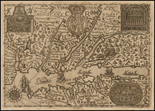
Rare miniature map of the Southern Colonies, extending to the confluence of the Ohio and Mississippi Rivers and Lake Louisiana, from John Gibson's Atlas Minimus, the first miniature English Atlas to include a number or regional maps of the Colonies. The map provides interesting coastal details and also names a number of forts settlements and forts in the interior of Georgia, including Augusta, Ft. Toulouze, Ft. Mobile and Corvetas. Notes on both colonies in the text offshore. A terrific American Miniature, which rarely appears on the market. This is one of the few works to include regional maps of the colonies at the time of the French & Indian War.
John Gibson flourished in London from 1748 to 1773. He was most likely born ca. 1724. As a young man he was apprenticed to John Blunbell of the Stationers Company, and then to John Pine. He was made free of the Company in 1748. Gibson proved a talented geographer and engraver who produced numerous maps, especially for books and magazines. He worked in collaboration with other map sellers such as Emanuel Bowen and John Roque. His best-known work was the pocket atlas, The Atlas Minimus (1758). Although little is known about his life beyond his publications, he was imprisoned for debt in King’s Bench from May to June of 1765.
![[Florida Panhandle to Yucatan] Pas-Kaart Van de Golff van Mexico . . .](https://storage.googleapis.com/raremaps/img/small/93130.jpg)