|
||

|

|
|

|
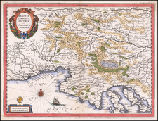
Striking large and highly detailed regional map, extending from Lake Geneva in the North to the French Riviera and from the Rhone to the Sesia Rivers. Includes large town plans of Turin and Verceil and a birdseye view of Verrve. The massive title cartouche includes smaller plans of Nice, Montmelian, Yvree and Carmagnole, and a birdseye view of Chambery. A remarkable large format map. This map was larger than the book, so the left margin is always problematic. In this example, the margin was trimmed inside the neatline, with the neatline and margin replaced in expert facsimile. A nice example of this map, which is rarely found in good condition.
Alexis-Hubert Jaillot (ca. 1632-1712) was one of the most important French cartographers of the seventeenth century. Jaillot traveled to Paris with his brother, Simon, in 1657, hoping to take advantage of Louis XIV's call to the artists and scientists of France to settle and work in Paris. Originally a sculptor, he married the daughter of Nicholas Berey, Jeanne Berey, in 1664, and went into partnership with Nicholas Sanson's sons. Beginning in 1669, he re-engraved and often enlarged many of Sanson's maps, filling in the gap left by the destruction of the Blaeu's printing establishment in 1672.
![[ Wines of Italy ] Vini D'Italia](https://storage.googleapis.com/raremaps/img/small/104047.jpg)
![[ Alsace - Rhine River From Basle to Spier ] Alsatiae Superioris et Inferioris Accuratissima Geographica Descriptio](https://storage.googleapis.com/raremaps/img/small/95530.jpg)
![[Ptolemy's France] Europ III Tab](https://storage.googleapis.com/raremaps/img/small/89187.jpg)