The item illustrated and described below is sold, but we
have another example in stock. To view the example which
is currently being offered for sale, click the
"View Details" button below.
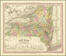
1835 Henry Schenk Tanner
$ 225.00


|
||

|

|
|

|
Stock# 0597
Description
Detailed and interesting map of New York, hand colored by county and showing towns, rivers, bays, lakes, railroads, roads, mountains, forts, etc.
Tables of Steam Boat routes and distances and a profile of the Erie Canal. Tanner's Atlas was the forerunner of a series of Atlases continued by Mitchell, Thomas Cowperthwait, Desilver, SA Mitchell Jr and others which extended to the early 1890s. Separate Tanner maps are increasingly scarce on the market and highy sought after.

![[Revolutionary War Plans of New York, Boston, Charleston, Delaware River to Philadelphia & Havana] Various Plans and Draughts of Cities, Towns, Harbours &c . . .](https://storage.googleapis.com/raremaps/img/small/83450.jpg)