|
||

|

|
|

|
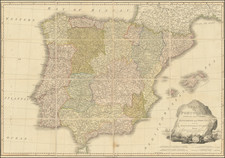
Striking large and highly detailed map of the Catalonia, with two large decorative cartouches. In addition, there are 3 separate 25 x 19 inch sheets, each with an accompanying set of 8 town plans and birdseye views, including Lerida, Ambare, Castel-danzen, Taragone, Arbec, Tortose, Valmoil, Flix, Lillers, Cardone, Ranty, Ceruere, Rebus, Balaguir, Heniun, Ager, Puicerda, Palamos, la Trinite, Barcelone, Roses, Citadelle de Barcelone, Girone and Mont-Iovy. These large format Jaillot maps with the extra view sheets are quite rare on the market. A fine decorative example with wide clean margins. From Jaillot's monumental atlas.
Alexis-Hubert Jaillot (ca. 1632-1712) was one of the most important French cartographers of the seventeenth century. Jaillot traveled to Paris with his brother, Simon, in 1657, hoping to take advantage of Louis XIV's call to the artists and scientists of France to settle and work in Paris. Originally a sculptor, he married the daughter of Nicholas Berey, Jeanne Berey, in 1664, and went into partnership with Nicholas Sanson's sons. Beginning in 1669, he re-engraved and often enlarged many of Sanson's maps, filling in the gap left by the destruction of the Blaeu's printing establishment in 1672.