This item has been sold, but you can enter your email address to be notified if another example becomes available.


|
||

|

|
|

|
Stock# 0456
Description
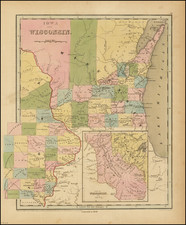
Gorgeous example of this early map of Wisconsin, issued only 6 years after it first became a territory. The lands south of the Wisconsin and Fox Rivers are largely surveyed and many early counties, towns, etc. appear. The region to the north is dominated by the lands of the Winnebagos, Menomonies, New York (Oneida) Indians and the Sioux and Chippewa Boundary to the North. Massive Carver claim remains, now nearly 100 years old. The south is filled with roads, and towns, the north rivers, portages, etc. One of the best early maps of Wisconsin in full original color. A nice example of Tanner's map, which rarely appears on the market. An essential map for Wisconsin collectors.
![[ Southern Railroads ] Railroad Map of the Southern States Shewing the Southern & Southwestern Railway Connections With Philadelphia. 1862 . . . Prepared by Thomas Kimber Jr., Chairman of the Committee on Inland Transportation of the Board of Trade of Philadelphia](https://storage.googleapis.com/raremaps/img/small/103211.jpg)