
This item has been sold, but you can enter your email address to be notified if another example becomes available.


|
||

|

|
|

|
Stock# 0454
Description
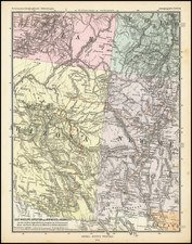
Highly detailed regional map, one of 6 sheets covering the United States issued by Stieler in his Hand Atlas, one of the most detailed and commercially successful German Atlases of the 19th and early 20th Centuries. The detail in Steiler's maps, which in this case are in English, surpass the work of all other contemporary publishers. The maps name towns, Indian Tribes and Villages, post offices, mountains, rivers, mines, lakes, roads, railroads, springs, elevations and a tremendous amount of additional detail. Stieler's maps are an important part of 19th Century regional American collections.
![Tunison's California, Oregon and Nevada [Yosemite Valley & Big Trees Vignettes]](https://storage.googleapis.com/raremaps/img/small/92845.jpg)

![[Central Riverside County] Riverside Quadrangle](https://storage.googleapis.com/raremaps/img/small/83568.jpg)