|
||

|

|
|

|
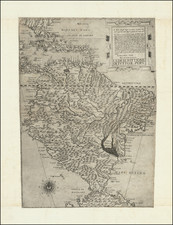
Fine separately issued example of this detailed chart of the southern coast of Peru, centered on the Rio Quilca, based upon surveys by Ange Rene Armand, Baron de Mackau (1788-1855).
The map was prepared during the Baron de MacKau's expedition to the Pacific, in order to conduct negotions with the newly formed states of Chile and Peru. The chart includes sailing directions, soundings, anchorages and extensive topographical detail along the coast.
The map also appeared in volume 7 of the Neptune Francois, an extensive atlas of charts of the western coasts of North and South America, with most charts dated or updated to the 1820's.
This example was offered for sale separately the firm of FIllastre Freres of Bordeaux, "Depot des Cartes, Plans et Instructions pour la Marine."
The Dépôt de la Marine, known more formally as the Dépôt des cartes et plans de la Marine, was the central charting institution of France. The centralization of hydrography in France began in earnest when Jean-Baptiste Colbert became First Minister of France in 1661. Under his watch, the first Royal School of Hydrography began operating, as did the first survey of France’s coasts (1670-1689). In 1680, Colbert consolidated various collections of charts and memoirs into a single assemblage, forming the core of sources for what would become the Dépôt.
The Dépôt itself began as the central deposit of charts for the French Navy. In 1720, the Navy consolidated its collection with those government materials covering the colonies, creating a single large repository of navigation. By 1737, the Dépôt was creating its own original charts and, from 1750, they participated in scientific expeditions to determine the accurate calculation of longitude.
In 1773, the Dépôt received a monopoly over the composition, production, and distribution of navigational materials, solidifying their place as the main producer of geographic knowledge in France. Dépôt-approved charts were distributed to official warehouses in port cities and sold by authorized merchants. The charts were of the highest quality, as many of France’s premier mapmakers worked at the Dépôt in the eighteenth century, including Philippe Bauche, Jacques-Nicolas Bellin, Rigobert Bonne, Jean Nicolas Buache, and Charles-François Beautemps-Beaupré.
The Dépôt continued to operate until 1886, when it became the Naval Hydrographic Service. In 1971, it changed names again, this time to the Naval and Oceanographic Service (SHOM). Although its name has changed, its purpose is largely the same, to provide high quality cartographic and scientific information to the France’s Navy and merchant marine.
![(South America) ФИЗИЧЕСКАЯ КАРТА ЮЖНОЙ АМЕРИКИ. [Physical Map of South America]](https://storage.googleapis.com/raremaps/img/small/90260.jpg)