This item has been sold, but you can enter your email address to be notified if another example becomes available.


|
||

|

|
|

|
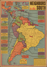
Stock# 0334gh
![[The Rarest State] Americae Sive Novi Orbis Nova Descriptio](https://storage.googleapis.com/raremaps/img/small/80521.jpg)

![America [Manuscript Map Showing the Sea of the West!]](https://storage.googleapis.com/raremaps/img/small/41297dm.jpg)