|
||

|

|
|

|
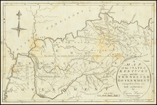
Nice example of this detailed and interesting map, hand colored by county and showing towns, rivers, lakes, railroads, roads, distances, forts, etc. Tables of Steam Boat routes and distances. Large insets of area around Lexington, the Washington and Clarksburg area and the Falls of Ohio, including Jeffersonville, Louisville, Shippingport and Portland. Tanner's maps are now rare on the market. A bit toned, but still a nice wide margined example with nice color. Tanner's New Universal Atlas became the standard work in the Industry until Tanner sold the rights to the atlas in 1846 to SA Mitchell. The early editions, engraved by J. Knight, are well regarded for the high quality paper and fine engraving, comparable to the American Atlas. Tanner's Universal Atlas is now rare on the market and the separate maps are now increasingly difficult to obtain.