


|
||

|

|
|

|
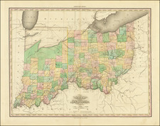
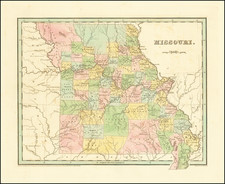
A gorgeous example of the first edition of Bradford's map. The map is hand colored by counties and shows towns, rivers, forts and other details. One of the earliest maps of Missouri to appear in a commercial atlas. The counties in the South and North are still oversized and primitive. Massive Platte County and two massive areas which are simply identified as Attached to Ray and Attached to Chariton (County). A wonderful early map. Bradford's atlas was a departure from other atlases of the period. Along with HS Tanner, Bradford produced an elegant, well engraved large format atlas on high quality paper. The 1830s were a fascinating transitional period in the US and in domestic cartographic publishing. Bradford's work is without question an important part of this era. The maps were engraved by GW Boynton or S.Stiles, Sherman & Smith. Wide clean margins.
Thomas Gamaliel Bradford (1802-1887) was an American geographic publisher. He hailed from Bradford, Massachusetts and began his publishing career by working for the America Encyclopedia. Then, he edited and republished the Atlas Designed to Illustrate the Abridgement of Universal Geography, Modern & Ancient, which had originally been offered in French by Adrian Balbi. In 1835, he published another atlas, A Comprehensive Atlas: Geographical, Historical & Commercial, and, in 1838, An Illustrated Atlas Geographical, Statistical and Historical of the United States and Adjacent Countries. His interests were primarily in educational publishing and he was one of the first mapmakers to show Texas as an independent country.
![[Geology Map of the Texas, California & the Southwest] Esquisse Geologique Des Anciennes Possessions Mexicains Du Nord Incorporees Ala Federation des Etats-Unis . . . 1867](https://storage.googleapis.com/raremaps/img/small/71446.jpg)
![Carte Qui Contient La Maniere Dont Se Fait La Chasse Des Bouefs Sauvages . . . [Buffalo, Niagara Falls, Calumet Village, Huron & Illinois Indians]](https://storage.googleapis.com/raremaps/img/small/93146.jpg)