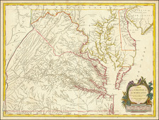


|
||

|

|
|

|
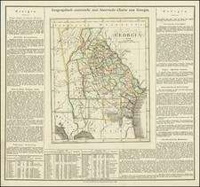
Detailed map of Georgia, from the rare German edition of the Geographical, Historical and Chronological Atlas of America, first published in Philadelphia by Carey & Lea in 1822. The western counties are still unformed and classified as Indian lands, including the Cherokis and Lower Creek. Massive Appeling, Irwn and Early Counties dominate the south and are noted as being Indian Territories pursuant to the treaty of Ft. Jackson. The map shows counties, towns, roads, rivers, etc. Interesting text notes numerous details concerning Georgia, including Rivers, Climate, Towns, Education, Religion, Commerce, Indian Details, Government, History, all the Governors beginning with Oglethorpe and important Revolutionary War battles. Minor staining in upper margin far from the map image, else a nice example. This map rarely appears on the market.
![Carta geografica della Florida nell'America settentrionale [Geographical map of Florida in North America]](https://storage.googleapis.com/raremaps/img/small/84142.jpg)

![[ The Marks of Sundry of the Chief Men of Virginia ] Aliquot Heroum Virginiae Notae.](https://storage.googleapis.com/raremaps/img/small/98859.jpg)