This item has been sold, but you can enter your email address to be notified if another example becomes available.


|
||

|

|
|

|
Stock# 0222gh
Description
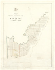
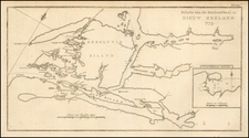
Fine early chart of the northern part of New Zealand's North Island, including the Bay of Islands.
The chart shows the 1827 track of the Astrolabe, during its visit to the region. Dumont d'Urville was a French navigator who led an important expedition to the Pacific aboard the Astrolabe (named in memory of La Perouse's flagship) and made significant contributions to the mapping of New Zealand. This chart was made in conjunction with Victor Charles Lottin.