This item has been sold, but you can enter your email address to be notified if another example becomes available.


|
||

|

|
|

|
Stock# 0189
Description
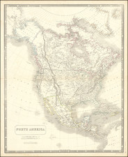
Crisply engraved map of North America at the height of its early territorial transition. The Louisiana Purchase has just been consumated. Kentucky and Tennessee are both shown. East & West Florida are still in existence. The NW Coast of America has now been charted on the coastline, but is still largely unknown between Ft. Vancouver and Monterrey. Hearne & MacKenzie have explored the interior of NW Canada, but the American Rocky Mountains are still completely unknown. A conjectural Missouri River extends tentatively to the Rocky Mtns. An interesting map based upon Morse's map of 1797. Wheat 244.
![Amerique Septentrionale divisee en Ses Principales parties . . . . 1674 [Rare First State]](https://storage.googleapis.com/raremaps/img/small/99317.jpg)
![[ First Map to Name The United States ] L'Amerique septentrionale ou se remarquent les Etats Unis . . . 1779](https://storage.googleapis.com/raremaps/img/small/94192.jpg)