|
||

|

|
|

|
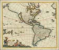
Scarce example of Buache's map of America, one of the earliest appearances of the Sea or Bay of the West.
The 1745 issue is the 7th edition of Guillaume De L'Isle's map of America, but most importantly, the first to display the Bay or Sea of the West. Buache was one of the leading mid 18th Century theoretical cartographers and was responsible for the dissemination of many early discoveries. He also helped to progate a fair amount of mythical cartography, as is the case with this map. This map gives extraordinary treatment to the region, although there is curiously no mention of the Russian discoveries of Behring and Tchirikow. The mythical discoveries of Martin D'Augilar and Juan De Fuca are shown, as is a potential watercourse from the Bay of the West to the Michinipi River and then on the the Atlantic, although obscured off the top of the map. The Islands discovered by Quiros in 1610 area shown. Original outline color. An essential map for Bay or Sea of the West Collectors, produced by Buache, who was responsible for so many of the early maps of this genre. .
Guillaume De L'Isle (1675-1726) is probably the greatest figure in French cartography. Having learned geography from his father Claude, by the age of eight or nine he could draw maps to demonstrate ancient history. He studied mathematics and astronomy under Cassini, from whom he received a superb grounding in scientific cartography—the hallmark of his work. His first atlas was published in ca. 1700. In 1702 he was elected a member of the Academie Royale des Sciences and in 1718 he became Premier Geographe du Roi.
De L'Isle's work was important as marking a transition from the maps of the Dutch school, which were highly decorative and artistically-orientated, to a more scientific approach. He reduced the importance given to the decorative elements in maps, and emphasized the scientific base on which they were constructed. His maps of the newly explored parts of the world reflect the most up-to-date information available and did not contain fanciful detail in the absence of solid information. It can be fairly said that he was truly the father of the modern school of cartography at the commercial level.
De L’Isle also played a prominent part in the recalculation of latitude and longitude, based on the most recent celestial observations. His major contribution was in collating and incorporating this latitudinal and longitudinal information in his maps, setting a new standard of accuracy, quickly followed by many of his contemporaries. Guillaume De L’Isle’s work was widely copied by other mapmakers of the period, including Chatelain, Covens & Mortier, and Albrizzi.
Philippe Buache (1700-1773) was one of the most famous French geographers of the eighteenth century. Buache was married to the daughter of the eminent Guillaume Delisle and worked with his father-in-law, carrying on the business after Guillaume died. Buache gained the title geographe du roi in 1729 and was elected to the Academie des Sciences in the same year. Buache was a pioneering theoretical geographer, especially as regards contour lines and watersheds. He is best known for his works such as Considérations géographiques et physiques sur les découvertes nouvelles dans la grande mer (Paris, 1754).

![(South America) ФИЗИЧЕСКАЯ КАРТА ЮЖНОЙ АМЕРИКИ. [Physical Map of South America]](https://storage.googleapis.com/raremaps/img/small/90260.jpg)