


|
||

|

|
|

|
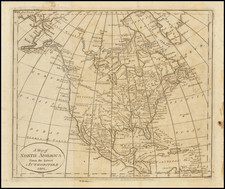
Scarce derivative of Sanson's 1656 and Jaillot's 1676 maps. California is now a peninsula. Great Lakes are closed. Shows Interesting detail between Colorado and Rio Grande and along Mississippi River. Two decorative cartouches. Elwe's map is a one of the more interesting anomalies among map collectors. It is indeed curious to have made use of early 18th Century copperplates to produce such a remarkably attractive and undoubtedly expensive work, but this apparently did not deter Elwe, who also produced stunning double hemisphere world maps and other maps, each of which was meticulously re-engraved to include his name and the date. Inspite of the late dating, it depicts a wonderful archipelagic Florida, marvelous early depiction of the Mississippi River, NW Passage and early re-attachment of California to the mainland, although still referred to as the Isle de Californie. Elwe Elwe acquired the Ottens plate, revised its imprint and published the map in his 1792 folio Atlas. A gorgeous example in old color.
![[ Exceptional original hand-color with highlights in gold ] Typus Aspectuum Oppositionum Et Coniunctionum Etz In Planetis](https://storage.googleapis.com/raremaps/img/small/81866.jpg)
![A Map of North America, Constructed According To The Latest Information: by H.S. Tanner. Improved to 1825 [Case Map]](https://storage.googleapis.com/raremaps/img/small/68580.jpg)