
This item has been sold, but you can enter your email address to be notified if another example becomes available.


|
||

|

|
|

|
Stock# 0160gh
Description
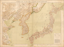
Rare map of the area near Beijing, from a 9 sheet map published by Dessine, for the Geographical Service of the French Army (Service Geographique de l'Armee).
The map is discussed at length in the journal of the Eighth Annual Geographical Conference, in an article written in French. The article states that the information utilized is derived primarily from maps provided by Missionaries and the French Military Attache, in Beijing.
The map includes topographical details, roads, rivers, towns, provinces, bays, islands, harbors, soundings, etc. In the Journal of the Royal Geographical Society, Volume 15 (1900), the following entry appears for this map:
Asie. Scale 1: 1,000,000 or 15'8 stat. miles to an inch. Sheets: Kang Neung, PeTrin, Moukden, Tcheng-Te-Fou, Vladivostok, Nankin, Quelpaert, Seoul. Dessine. heliograve" et publie par le Service Geographique de l'Armee, Paris. Price 1-25 jr. each sheet.
As will be seen by the title, these sheets include those parts of China, Russia, and Korea with regard to which a great deal of political interest is felt at the present time. The map is very nicely drawn, soundings are given along the coast, and all means of communication are shown.
The first time we have ever seen this map.

![[Map of the Mount Everest Region] Mahalangur Himal Chomolongma -- Mount Everest](https://storage.googleapis.com/raremaps/img/small/95259.jpg)
![(Russian Adventurism in China) Карта Средней Азии Составлена К. Веберомъ... 1871. [Map of Central Asia Compiled by K. Weber... 1871.]](https://storage.googleapis.com/raremaps/img/small/58597.jpg)