


|
||

|

|
|

|
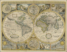
A striking example of first state of Speed's map of the world (Shirley 317). The map is based upon Grent's rare map of the world. This is one of the earliest attainable world maps printed in English. The map shows California as and Island, an unusual NW Coast of America, conjectural Magellanica or The Southerne Unknowne Land and extraordinary early detail throughout the map. It is surrounded by smaller celestial hemispheres, figural representations of Water, Earthe, Aire and Fire, a number of celestial phenomena & portraits of early explorers. Includes several lengthy notes on the South Pole & Straits of Magellan. A virtually flawless example with excellent margins and none of the usual centerfold problems. The coloring may be early color, although early color examples of Speed's World map are highly unusual. The best example of the first edition of this map that we have seen.
John Speed (1551 or '52 - 28 July 1629) was the best known English mapmaker of the Stuart period. Speed came to mapmaking late in life, producing his first maps in the 1590s and entering the trade in earnest when he was almost 60 years old.
John Speed's fame, which continues to this day, lies with two atlases, The Theatre of the Empire of Great Britaine (first published 1612), and the Prospect of the Most Famous Parts of the World (1627). While The Theatre ... started as solely a county atlas, it grew into an impressive world atlas with the inclusion of the Prospect in 1627. The plates for the atlas passed through many hands in the 17th century, and the book finally reached its apotheosis in 1676 when it was published by Thomas Bassett and Richard Chiswell, with a number of important maps added for the first time.
![[Contructing a Galley] Dichiaratione Della Presente Figura Per La Construttione d'una Gallera Colle Sue Dipendenze](https://storage.googleapis.com/raremaps/img/small/76563.jpg)

![[Piscis Austrinus] (Stars Heightened in Gold)](https://storage.googleapis.com/raremaps/img/small/83184.jpg)