|
||

|

|
|

|
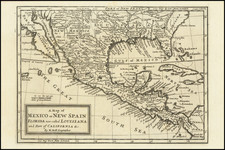
A marvelous regional map showing area bounded by the Mississippi River, Gulf Coast and the Southern Appalachians, drawn from Mitchell's monumental work. This map is in fact one sheet of Zatta's 20 sheet map of North America. It includes many details regarding the local Indians (Apalaches, Creeks, etc), the quality of the lands and other notes. Several early roads are shown, starting with Welk's road, complete with mileage notiations. One of the most interesting 18th Century maps of the Gulf Coast Region. A several forts are shown and crossed swords locate various battles.
Antonio Zatta (fl. 1757-1797) was a prominent Italian editor, cartographer, and publisher. Little is known about his life beyond his many surviving published works. It is possible that he was born as early as 1722 and lived as late as 1804. He lived in Venice and his work flourished between 1757 and 1797. He is best known for his atlas, Atlante Novissimo (1779-1785), and for his prolific output of prints and books that were both precisely made and aesthetically pleasing. Zatta clearly had a large network from which to draw information; this is how he was able to publish the first glimpse of the islands visited by Captain Cook in the Atlante Novissimo. Zatta also published books of plays and architecture.
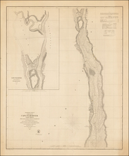

![[Florida and Gulf Coast] The Coast of West Florida and Louisiana . . . [with] The Peninsula and Gulf of Florida or Channel of Bahama with the Bahama Islands . . .](https://storage.googleapis.com/raremaps/img/small/66344.jpg)
![[ Pictish Man Holding Severed Head ] Picti icon](https://storage.googleapis.com/raremaps/img/small/99837.jpg)