The item illustrated and described below is sold, but we
have another example in stock. To view the example which
is currently being offered for sale, click the
"View Details" button below.
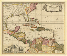
1708 Nicolaes Visscher I
$ 1,200.00


|
||

|

|
|

|
Stock# 0150ops
Description
Nice old color example of Nicholas Visscher's map of the Caribbean Florida, Southern US, Central America and part of South America.
A number of cartographic myths appear on the map, including the large lake which appears in Georgia, a non-existent mountain range extending from the Piedmonts right across the continent, and the archetypal cartographic myth, El Dorado located on Lacus Parime in Guyana. Interesting early treatment of the Mississippi River Valley, which is far to the West of its proper course and shows little of the French Jesuit information which was to be reported in the following decades.
Excellent detail in the Caribbean. Includes 2 decorative cartouches, and sailing ships.
There are 4 states of the map:
- 1680 ca: lacking privilege
- 1682 ca: "Cum Privelegio Ordinum Hollandiae et Westfrisiae"
- 1708 ca: Grid lines added
- 1720 ca: Peter Schenk Junior added, cartouches retouched.
Condition Description
Old Color. Minor offsetting and minor fold split at bottom of image, repaired on verso.
Reference
Lowery 179; Portinaro 82.
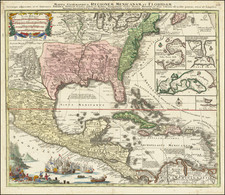

![[ English Plantations in North America ] A New Map of the most Considerable Plantations of the English In America Dedicated to His Highness William Duke of Glocester.](https://storage.googleapis.com/raremaps/img/small/98233.jpg)