


|
||

|

|
|

|
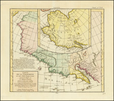
Nice example of the rare second state of Jansson's map of the Pacific, which has been revised to include discoveries by Tasman and others in Australia and New Zealand.
As noted by Burden, this second state is rare, with the second state appearing in a copy of a Abraham Wolfgang atlas noted by Burden in the Library of Congress. Burden states that the primary changes to the map include the following:
The remainder of the Gulf of Carpentaria 's coastline is added to the west in Hollandia Nova. Tasman's discoveries in New Zealand and TAsmania are also now recorded. t' lant van Eso and Compagnies latn appear to the north of Japan.
The primary features of the first edition include a long chain of islands appear in the South Pacific, which are likely a vestige of Terra Australis and which are noted by Jansson to have been discovered by Hernando Gallego in 1576. Marvelous treatment of Australia, which is then only partially known.
While based upon the Briggs model, the lack of the 2nd Punta de la Concepcion suggests reliance upon Goos or his sources. The large Terra Incognita in the Northwest nearly connects Asia with the Island of California, separated only by the Fretum (Strait) Anian. Many place names in California. Nice treatment of the Ladrones and neighboring islands, along with the West Coast of America.
AMPR notes only one appearance of this map in a dealer catalogue in the past 30 years (Gowrie Galleries, 2004).
Jan Janssonius (also known as Johann or Jan Jansson or Janszoon) (1588-1664) was a renowned geographer and publisher of the seventeenth century, when the Dutch dominated map publishing in Europe. Born in Arnhem, Jan was first exposed to the trade via his father, who was also a bookseller and publisher. In 1612, Jan married the daughter of Jodocus Hondius, who was also a prominent mapmaker and seller. Jonssonius’ first maps date from 1616.
In the 1630s, Janssonius worked with his brother-in-law, Henricus Hondius. Their most successful venture was to reissue the Mercator-Hondius atlas. Jodocus Hondius had acquired the plates to the Mercator atlas, first published in 1595, and added 36 additional maps. After Hondius died in 1612, Henricus took over publication; Janssonius joined the venture in 1633. Eventually, the atlas was renamed the Atlas Novus and then the Atlas Major, by which time it had expanded to eleven volumes. Janssonius is also well known for his volume of English county maps, published in 1646.
Janssonius died in Amsterdam in 1664. His son-in-law, Johannes van Waesbergen, took over his business. Eventually, many of Janssonius’ plates were sold to Gerard Valck and Pieter Schenk, who added their names and continued to reissue the maps.
![National Map Company's California Showing Counties, Cities, Villages, and Post Offices[,] Steam and Electric Railroads, with Stations and Distances between Stations[,] National Forests, Reservations, Parks, Etc.](https://storage.googleapis.com/raremaps/img/small/92408.jpg)

![[Lower Colorado River and Gila River] Plan de L'Embouchure Du Rio Colorado dans la Mer Vermeille](https://storage.googleapis.com/raremaps/img/small/29375.jpg)