


|
||

|

|
|

|
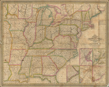
Fine example of the second edition of this attractive and detailed map of the United States & Canada, extending nearly to the Rocky Mountains.
Texas is shown as a Republic. The region west of the Missouri River is dominated by the Mandan, Osage and Ozark Districts, with a small region called Territoire Des Indiens Du Nord Du Mexique. Massive Iowa extends to Canada. Oversized Nord-Oest Territory ou Ouisconsin. Missouri is misshappen. The map delineates a number of other Indian Regions in Georgia, Alabama, Misssissippi, and other parts. Many forts and Indian Tribes located, along with roads. Insets of Florida and Newfoundland. Several interesting annotations in the body of the map.
The notes in the lower left corner explain that this second edition was first published in 1832 and later revised in 1836.
Andre Hubert Brué was a French geographer and cartographer. Born in Paris, he served in the French Navy, joining the Baudin expedition to the Pacific (1800-1804). After his sea service, Brué applied his navigation and charting skills to creating finely-crafted maps, which were renowned for their crisp engraving and accuracy. He drew directly on the copper of the plate, creating what he called encyprotypes. He is best known for the Atlas universal de géographie physique, politique, ancienne et moderne.
![Great Overland Route! Chicago Rock Island and Pacific RR for California, Oregon Australia, China and Japan. [Cover title.]](https://storage.googleapis.com/raremaps/img/small/72924.jpg)
![[United States] Index Map](https://storage.googleapis.com/raremaps/img/small/67626.jpg)