|
||

|

|
|

|
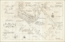
Guiding Sailors into the Pacific—Heightened in Gold
Fine, gold-heightened example of Pieter Goos's sea chart of the southern part of South America, extending from the lower Rio de la Plata region in the north to the Strait of Magellan and Tierra del Fuego in the south.
Goos's sea chart is the first in a series of Dutch charts of this area. His work was followed by similar charts by Hendrick Doncker and Frederick de Wit. Comparison shows that the Goos chart is the earliest, with a missing portion of the coastline of Magellanica.
The chart is criss-crossed with rhumb lines and shows notable ports like Port Desire, San Julian, Castro, Osorno, and Valdivia. The island of Juan Fernandez, which was a convenient stopping place for ships passing around the south of South America, is in the northwest.
The chart emphasizes the Dutch voyages to the region around the turn of the seventeenth century. The first of these were part of the attempt to trade with China and the Spice Islands and the creation of the Dutch East India Company (VOC). Of the fourteen fleets that set out from Dutch ports for the East Indies between 1598 and 1601, only two did so via the Strait of Magellan.
The first of these was commanded by Jacques Mahu and Simón de Cordes. With five ships and 490 men, Cordes battled the elements to winter at Cordes Bay in the western Straits. He lost 120 men there to privation and encounters with local people. One of the ships were commanded by Sebald de Weert, who turned back. On his way north, he sighted islands that were likely the Falklands, but which appeared on charts for over a century as the Seebald de Weerts (here the Sybold de Waerds Eylanden).
The second of the fleets was in the charge of Olivier van Noort. After killing tens of Selk’nam peoples in the Straits, they eventually caught up to parts of Mahu and Cordes’ ragged squadron. Van Noort set out west and eventually completed a circumnavigation, the first Dutch venture to do so.
The third significant Dutch voyage had the most impact on the geography shown here. The VOC had declared the Straights of Magellan as their own, disallowing non-VOC ships from entering. In an attempt to circumvent these restrictions, the merchant Isaac LeMaire financed a voyage to find an alternative route in 1615. William Schouten and Isaac’s son, Jacob Le Maire, entered the Pacific via a straight that sent their ships around Cape Horn, which they named for their port of departure in the Netherlands. Le Maire’s name was chosen for the strait, while the island they passed by received the name of Staten Land. The Schouten and Le Maire expedition also named the Barnevelt Islands after Johan van Oldenbarnevelt, governor of the province of Holland.
The title to Goos’ chart is embellished by a decorative frame with Indigenous peoples from around the world. Putti with dividers and a cross-staff lounge around the scale in the lower right corner. A solitary ship sails toward the east.
Pieter Goos (ca. 1616-1675) was a Dutch map and chart maker, whose father, Abraham Goos (approx. 1590-1643), had already published numerous globes, land and sea maps together with Jodocus Hondius and Johannes Janssonius in Antwerp. Pieter gained recognition due to the publication of sea charts. He bought the copperplates of the famous guide book for sailors, De Lichtende Columne ofte Zeespiegel (Amsterdam 1644, 1649, 1650), from Anthonie Jacobsz. Goos published his own editions of this work in various languages, while adding his own maps. In 1666, he published his De Zee-Atlas ofte Water-Wereld, which is considered one of the best sea atlases of its time. Goos' sea charts came to dominate the Dutch market until the 1670s, when the Van Keulen family came to prominence.
![[ Antarctica ] [Signed and Annotated by Robert A. English, Commanding Officer of the Bear of Oakland] Reconnaissance Map. King Edward VII Land. The Northern Part of Marie Byrd Land. Based mainly on air photographs taken by Capt. A.C. McKinley on the Byrd Antarctic Expedition 1928-1930 . . .](https://storage.googleapis.com/raremaps/img/small/89439.jpg)