|
||

|

|
|

|
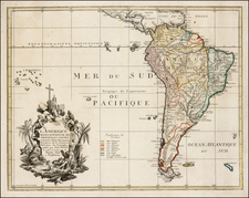
Detailed map of America, based on De L'Isle's map of 1700,
The map shows tremendous detail throughout. Most notable is the representation of the Mississippi, pushed west of its actual course and showing a number of long east reaching sources. Dozens of Indian Names abound. The coastline of California has no fewer than18 place names, including the Channel islands, San Francisco and several mythical rivers, including the Carmel River. Excellent detail in the Southwestern United States, and throughout South America, with is treated in excellent detail.
In this editin, he British Colonies in North America are shown, shortly before hostilities began to accelerate before the French & Indian War 10 years later.
Cartouche, compass rose and extensive notes throughout the map.
Philippe Buache (1700-1773) was one of the most famous French geographers of the eighteenth century. Buache was married to the daughter of the eminent Guillaume Delisle and worked with his father-in-law, carrying on the business after Guillaume died. Buache gained the title geographe du roi in 1729 and was elected to the Academie des Sciences in the same year. Buache was a pioneering theoretical geographer, especially as regards contour lines and watersheds. He is best known for his works such as Considérations géographiques et physiques sur les découvertes nouvelles dans la grande mer (Paris, 1754).
![[The First Maps Printed Color] Cartes en Couleur des Lieux Sujets aux tremblements de Terre Dans toutes les parties du Monde Selon le Sisteme de l’impulsion Solaire](https://storage.googleapis.com/raremaps/img/small/52293op.jpg)