This item has been sold, but you can enter your email address to be notified if another example becomes available.


|
||

|

|
|

|
Stock# 0078
Description
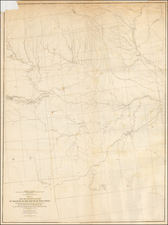
Rare map of the three territories from Gaylord Watson's exceedingly rare Railroad Atlas of the United States. Watson's Railroad Atlas was drawn from his Wall Map of the United States. It apparently did not achieve the commercial success of the atlases issued the following year by Cram and Rand McNally & Company in Chicago, and is now by far the rarest of the 3 mid-1870s productions. The map shows a 5 county Wyoming configuration. Includes excellent detail of the railroad lines, stations and distances between each. Nice topographical detail. We have seen the atlas only once and never seen a separately issued map from the atlas on the market in 15 years.