|
||

|

|
|

|
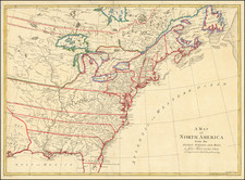
Lieutenant Ross' large scale map of the Mississippi River is the largest format map of the Mississippi during the 18th Century and the most detailed British Military Survey of the River. The map is based upon D'Anville's large map of 1746 and his Carte de la Louisiane published in 1752. Fort Chartes in the North was the main center of French administration in the Illinois region. Also shows is Fort Kaskaskia. These two forts passed to the Britsihs under the treaty of 1765. This is the second of four states, adding substantial detail in the southern portion of the map. The map names dozens of Indian Villages and other forts and includes notes of early explorations dating to the 16th Century. Issued in Jeffery's Atlas of North America, one of the most important colonial works. Several two inch tears at the bottom have been archivally repaired, else a near fine example. Because of the size of Jeffery's atlas, this map rarely appears in better condition.
Robert Sayer (ca. 1724-1794) was a prominent London map publisher. Robert’s father was a lawyer, but his older brother married Mary Overton, the widow of prominent mapmaker Philip Overton and the proprietor of his shop after his death. Mary continued the business for roughly a year after her marriage and then, in early 1748, it passed to Robert. Robert became a freeman of the Stationers’ Company later that year; his first advertisement as an independent publisher was released in December.
Sayer benefited from Overton’s considerable stock, which included the plates of John Senex. In the 1750s, Sayer specialized in design books and topographical prints, as well as comic mezzotints. In 1753, he, along with John Roque, published a new edition of Thomas Read’s Small British Atlas, the first of several county atlases that Sayer would publish.
Sayer’s business continued to grow. In 1760 he moved further down Fleet Street to larger premises at 53 Fleet Street. In 1766, he acquired Thomas Jefferys’ stock when the latter went bankrupt. In 1774, he entered into a partnership with John Bennett, his former apprentice. The pair specialized in American atlases, based on the work of Jefferys. They also began publishing navigational charts in the 1780s and quickly became the largest supplier of British charts in the trade.
Bennett’s mental health declined, and the partnership ended in 1784. As Sayer aged, he relied on his employees Robert Laurie and James Whittle, who eventually succeeded him. He spent more and more time at his house in Richmond. In 1794, he died in Bath.

![[Separately Published Example!] Map of the United States of America. Designed to illustrate the Geological Memoir of Wm. Maclure Esq.](https://storage.googleapis.com/raremaps/img/small/90048.jpg)