


|
||

|

|
|

|
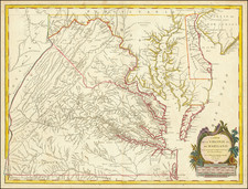
Rare and highly desireable chart of the Chesapeake and Delaware Rivers by Fielding Lucas. Shows inland navigation on the rives as far upstream as Philadelphia, Port Deposit, Baltimore, Washington, and for considerable distances up the Rappahannock, York and James Rivers. Soundings extend along the eastern shore into the lower Chester River, Eastern Bay, the mouth of the Choptank, and Tangier Sound. The entrances to both major bays depict the major shoals, and the bays on the Atlantic side of the peninsula are sketched in. There are four profile viewss of the shore, and tide tables for both bays. The map was published from 1832 to 1859. All editions are now rare on the market. This example is laid on original linen, still bearing the bookplate of Hagge & Brother of Baltimore, the original sellers (front and back bookplates present). The map is a remarkably clean and well preserved example, as these working sea charts were generally exposed to much more harsh conditions than atlas and pocket maps. The map appears on the cover of Guthorn's United States Coastal Charts. Fielding Lucas Jr. was one of the most important map publishers and sellers in the first part of the 19th Century. All of his separately issued works are now rare on the market.
Fielding Lucas, Jr. (1781-1854) was a prominent American cartographer, engraver, artist, and public figure during the first half of the 19th century.
Lucas was born in Fredericksburg, Virginia and moved to Philadelphia as a teenager, before settling in Baltimore. There he launched a successful cartographic career. Lucas's first atlas was announced in early- to mid-1812, with production taking place between September 1812 and December of 1813, by which point the engravings were complete. Bound copies of the atlas -- A new and elegant general atlas: Containing maps of each of the United States -- were available early in the next year, beating Carey to market by about two months. Lucas later published A General Atlas Containing Distinct Maps Of all the known Countries in the World in the early 1820s.

![[Rare Blaeu West Indische Pascaert Wall Map Section] Insulae Americanae in Oceano Septentrionali, cum terris adjacentibus](https://storage.googleapis.com/raremaps/img/small/75672.jpg)
![[ Port Royal, South Carolina ]](https://storage.googleapis.com/raremaps/img/small/81298.jpg)