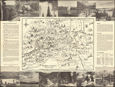


|
||

|

|
|

|
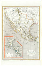
Detailed map of Texas, Upper California, New Mexico, Mexico and Baja California, depicting e time of the Texas's first claims of independence from Mexico.
Texas appears in its early Republic form. There are two Salt Lakes and two Rivers of the West (San Buenaventura and Sacramento flowing from San Francisco Bay to well east of the Sierras, one feeding the mythical Salt Lake.
This is one of the very few maps to report information from Jedidiah Smith's travels. Most notably, the R. Adams are shown as upper tributaries of the Colorado River, the latter named twice. These are the Rivers mentioned by Smith in his October 11, 1827 letter to William Clark. A reference to the Ammuchiebes Indians appears in both this map and the Smith-Clark letter as well. In all, a remarkable early map to include Jedidiah Smith information.
![[Drake's Bay to Fort Bragg] Bodega Head to Abalone Point From The Latest United States Government Charts . . .](https://storage.googleapis.com/raremaps/img/small/73078.jpg)
![[Texas and Western Louisiana]](https://storage.googleapis.com/raremaps/img/small/66617.jpg)