|
||

|

|
|

|
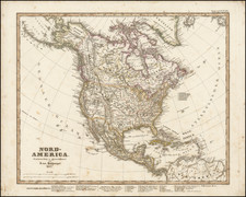
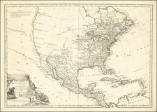
Fascinating map of North America, offering a great snapshot of the fast moving cartographic and geo-political changes in North America between 1790 and 1815.
While the map appears to be a relatively simple representation of North America, we note that it is one of the more interesting maps of the period which we have seen, providing a marvelous exercise in dating maps of North America.
In the Pacific Ocean, the Sandwich Islands are named, placing the map after 1780. Along the Northwest Coast of America, the discoveries of Cook and Vancouver are provided in good detail, meaning the map was clearly issued after 1798. The presence of the single cordillera depiction of the Rocky Mountains in the style of Humboldt suggests a date of circa 1810.
Turning to the midwest, the presence of both Indiana and Illinois (both Territories having been created in 1809), suggests the earliest possible date of late 1809. The lack of a detailed treatment of the region covered by Lewis & Clark and by Pike suggests the map was almost certainly printed before 1815.
Turning southward, we note that while the Louisiana Purchase is in evidence, the state of Louisiana, formed in 1812, is not shown. West Florida, annexed by the US in 1810 is shown. Therefore, it can reasonably be concluded that the map was published in or shortly after 1810.