


|
||

|

|
|

|
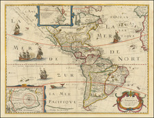
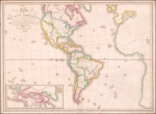
Nice dark impression of De Wit's decorative map of the Americas and Pacific.
Includes California as an Island, an early depiction of the Great Lakes (not present in Visscher's edition of the map), non-existent coastline north of the Island of California and misprojected South America. This first state of the map predates the information in the NW and Oceana. The map predates La Salle's information on the interior of North America, but includes excellent detail in Canada and the East Coast of North America, noting the Dutch Possessions, the Iroquois regions, N. Anglia, New Amsterdam, the Cheaspeak, Plymouth, and many Indian Place names.
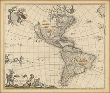
Second state of the map, which retains the vignettes of Indians and Indian Villages in South America and the Animals in North America.
De Wit (1629 ca.-1706) was a mapmaker and mapseller who was born in Gouda but who worked and died in Amsterdam. He moved to the city in 1648, where he opened a printing operation under the name of The Three Crabs; later, he changed the name of his shop to The White Chart. From the 1660s onward, he published atlases with a variety of maps; he is best known for these atlases and his Dutch town maps. After Frederik’s death in 1706, his wife Maria ran the shop for four years before selling it. Their son, Franciscus, was a stockfish merchant and had no interest in the map shop. At the auction to liquidate the de Wit stock, most of the plates went to Pieter Mortier, whose firm eventually became Covens & Mortier, one of the biggest cartography houses of the eighteenth century.

![(South Atlantic) Nieuwe Wassende Graadige Pas-kaart van de Kust van Guinea en Brasilia strekkende van Cap Verde tot de Cap de Bon-Esperance en Verders van Rio de Berbice tot Rio de la Plata. [New Increasing Latitude Sea Chart of the Coast of Guinea and Brazil stretching from Cape Verde to the Cape of Good Hope and Further from the Berbice River to the Rio de la Plata.]](https://storage.googleapis.com/raremaps/img/small/99819.jpg)