Search
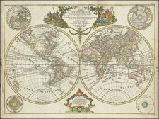
Two expeditions led by Vitus Behring (1728-30, 1733-43) explored Kamchatka and what is now Alaska, charting the strait between them. The first maps of the discoveries appeared in France in the early 1750s, followed by a German map by Gerhard Müller, a member of the second Kamchatka Expedition, first published in 1754 and distributed more widely in a 1758 edition. These maps, though they differed in many respects, show the strait between the continents and the westward thrust of the Alaskan mainland/archipelago.
In the 1760s, Russian fur traders discovered more and more of the Aleutian Islands, some of which are shown here. In 1764, another Second Kamchatka Expedition veteran, Lieutenant Ivan Synd, led a new voyage to the Bering Sea. He was in search of the Northwest Passage, but also hoped to clarify to what extent western Alaska was a peninsula or an archipelago. He produced several maps, all but one of which have been lost. The map that does survive shows a series of islands nearly touching Kamchatka, not a peninsula.
As a result of Synd’s findings, a modified 1773 Russian edition of Müller’s chart converts Müller’s large peninsula to a string of islands. In the same year Jacob von Stählin, secretary to the Russian Academy of Sciences, created his own map based on Synd’s discoveries entitled, “A Map of the New Northern Archipelago discover’d by the Russians.” This map, published in a book with a similar title, was a source for this 1774 edition of Covens & Mortier’s map of the Americas. Although it does not copy Stählin’s map exactly—it does not include a large Alaschka Island, for example—the Covens & Mortier map does adopt several toponyms from the Stählin map, including Stachtan Nitada on the North American mainland, near the Arctic Circle.
Written as Satchan Nitada on the Covens & Mortier example, this toponym seems to have been included for the first time by Stählin. It is supposedly a place Synd landed at and is near the sighting of the Alaskan mainland by the Russians in 1730, an event also marked on this map. The book excited members of the Royal Society of London, who ensured that the German language publication was translated into English by the end of 1774.
However, Stachtan Nitada’s precise location and importance remained unclear to explorers, none more so than James Cook. Cook carried the English translation of Stählin’s map with him on this third voyage, which was focused on finding the Northwest Passage. What interested Cook was the strait between Stachtan Nitada and the nearest island to the west, a feature repeated, in reduced form, on this map. It seemed to Cook and others planning his third voyage that this could be an entrance to a Northwest Passage.
When Cook arrived in search of the islands and passage in 1778, he found no such place. As J.C. Beaglehole, Cook’s twentieth-century editor, explains:
…no one could be too hard on Stählin. He had thrown the name Alaska on to an arbitrary island in the north; the other name Stachtan Nitada was unknown to either Russian or Aleut…As a cartographer he was naïve, even infantile; and he was unwise enough to speak slightingly of seamen. (Journals of Captain Cook, cxxxvii-cxxxviii)
Cook himself had choice words about Stählin and Stachtan Nitada. In his journal of October 1778, he wrote:
Stachtan Nitada as it is calld in the Modern maps, is a name quite unknown to these people, Indians as well as Russians, but both know it by the name of America. (251)
Of Stählin’s map, Cook wrote later in October 1778:
If Mr Stehlin was not greatly imposed upon what could induce him to publish so erroneous a Map? in which many of these islands are jumbled in in [sic] regular confusion, without the least regard to truth and yet he is pleased to call it a very accurate little Map? A Map that the most illiterate Seafaring men would have been ashamed to put his name to. (456)
Of course, Covens & Mortier could not have known of the inaccuracy of the map in 1774, as Cook would not test Stählin’s hypotheses until later in the decade. For that reason, Stachtan Nitada appears here and on several other contemporary maps and is an enduring example of the conjectural nature of mapmaking.
Archived