Search
Humans have known for centuries that there was a magnetic property to metals, and to navigation. Polarity and orientation were first recorded in China in the sixth century; they recorded the first compasses, a needle floating in a bowl of water, in the twelfth century. This technique for finding direction was also developed in Europe in the Medieval period. The first maps to include an inkling of declination are markings on German sundials from the mid-fifteenth century. Soon mapmakers adopted the convention, including declination markings on their wind roses.
Until the sixteenth century, the seat of magnetic attraction was thought to be housed in the heavens. In the early modern period, more and more data was gathered. This data was collected by navigators at sea and consisted of magnetic inclination, declination, and deviation. The former, also known as magnetic dip or the dip angle, is the angle made with the horizontal by the Earth’s magnetic fields. Magnetic declination, or variation, is the angle on a horizontal plane between magnetic and true north. Magnetic deviation is the affect of local magnetic fields on compass error. Directional data led savants to conclude that these phenomena varied considerably based on one’s location. They found there was terrestrial polar attraction, creating waves, or lines, of magnetic variation across the globe.
More data also shifted understanding of the source of magnetic variety. As more and more ships took to the open seas, they contributed new data sets. Many found magnetic declination to be zero near the Azores, suggesting that it was a natural prime meridian from which to measure longitude. A tilted dipold was thought to lie 180°E of the Azores, affected by the great magnetic mountain that supposedly lay in the Arctic—it appears famously on Mercator’s map of the North Pole. While this idea was mistaken, as were other hypotheses of two and up to six dipolds, the ideas of an Earth-bound source for magnetism, and of terrestrial locations for the magnetic poles, were not.
The first map to show isogonic lines—lines connecting points of equal declination—was a manuscript chart by the Jesuit Christoforo Borro; made in the 1620s, it is now lost. The seventeenth century was an important period in the theorization of geomagnetism; William Gilbert and others contributed to the ideas of global crustal heterogeneity, rather than a single Arctic magnetic pole. Observations conducted over time at a single point also showed that there was a temporal element to magnetic readings. Precisely why these changes occurred was what drove Edmond Halley to conduct the first naval surveys of magnetic declination in the 1690s.
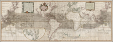
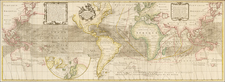
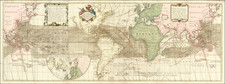
In the eighteenth century, isogonic lines such as those employed by Halley would become a useful tool for those eager to crack the secrets of geomagnetism. They appeared on maps by Frezier (1717), Van Musschenbroeck (1729, 1744), van Ewyk (1752), Mountaine and Dodson (1744, 1756), Dunn (1775), Lambert (1777), and Le Monnier (1778). The first map to include isoclinics, or lines of equal dip, was made by Johann Karl Wilcke in 1768. Towards the end of the century, John Churchman, a surveyor, published a magnetic atlas that employed both isogonics and isoclinics. They called on a huge amount of data gathered on shore by national observatories and local natural philosophers, as well as at sea by naval officers and Company employees. All of this information led to the abandonment of the idea of even multiple fixed poles and gave way to an understanding of shifting magnetism based on disjointed dipoles that were dynamic, tilted, and nonantipodal.
From the 1830s, astronomers and physicists became the primary gatherers of data. They measured the full magnetic vector; that is, they recorded both the direction and intensity of magnetism. These surveys allowed them to map the field as a whole, a process that accelerated in the mid-twentieth century when scientists were able to carry out various magnetohydrodynamic simulations.
Archived