
Search
Old and antique maps of Eastern Canada for sale. Our authentic Eastern Canada map inventory features antique maps of Canada from the period of New France, the Hudson Bay Company, and early exploration by mapmakers such as Champlain. Our map inventory typically includes antique and vintage city views and plans of Montreal, Quebec, and Toronto, as well as maps of Ontario, Upper and Lower Canada, Quebec, Newfoundland and Labrador, Prince Edward Island, Nova Scotia, and New Brunswick. Vintage pictorial maps of Eastern Canada are also for sale.
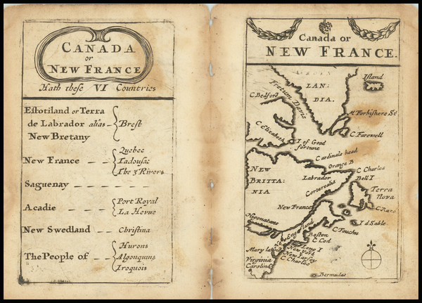
Place/Date:
London / 1679
Size:
2.25 x 3.75 inches each
Condition:
Good
Stock#:
92186
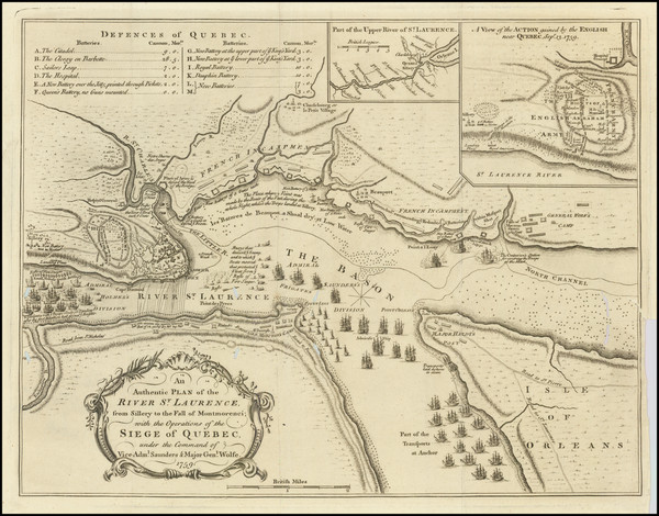
Place/Date:
London / 1759
Size:
14 x 11 inches
Condition:
VG
Stock#:
90989
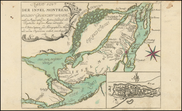
Place/Date:
Nuremberg / 1764
Size:
11.5 x 9 inches
Condition:
VG+
Stock#:
95558
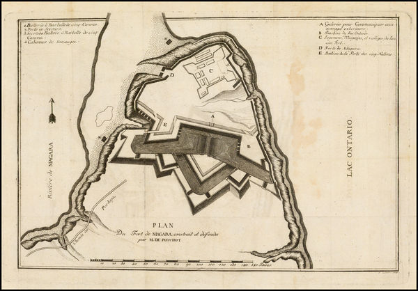
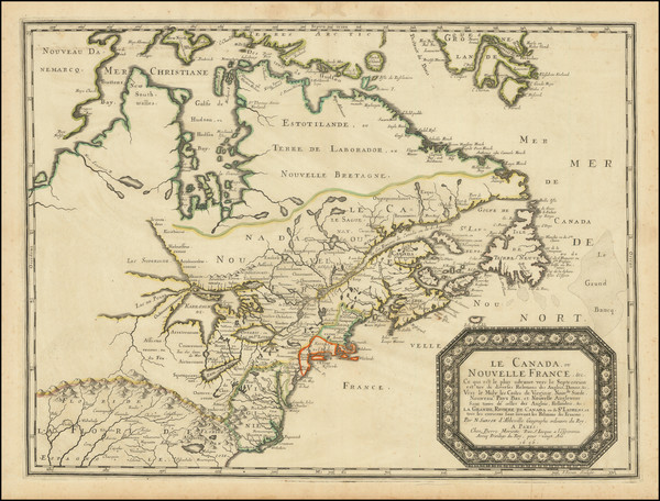
Place/Date:
Geneva / 1781
Size:
12.5 x 8.5 inches
Condition:
VG
Stock#:
39501
Pouchot's 1781 antique map showing Eastern Canada.

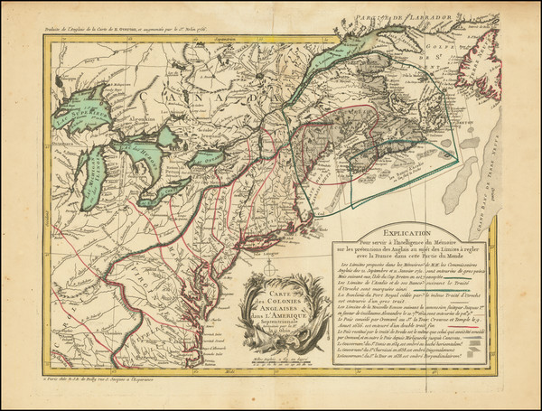
Place/Date:
Paris / 1778
Size:
22 x 15.5 inches
Condition:
VG
Stock#:
60913
1778 antique Le Rouge map showing Eastern Canada.
Place/Date:
London / 1775
Size:
24.5 x 18.5 inches
Condition:
VG
Stock#:
81952

Place/Date:
Toronto / 1891
Size:
27 x 21.5 inches
Condition:
VG+
Stock#:
83292
Place/Date:
London / 1775
Size:
37.5 x 24 inches
Condition:
VG
Stock#:
89677
Place/Date:
Paris / 1703
Size:
8 x 3.75 inches
Condition:
VG
Stock#:
90028

Place/Date:
London / 1775
Size:
22 x 21.5 inches
Condition:
VG
Stock#:
90814
Place/Date:
London / 1750 circa
Size:
22 x 17.5 inches
Condition:
VG
Stock#:
60417
Rare map showing Eastern Canada by Mount & Page made in 1750.
Place/Date:
London / 1794
Size:
26 x 19 inches
Condition:
VG
Stock#:
45177
Antique map showing Eastern Canada by Laurie & Whittle, 1794.
Place/Date:
Frankfurt / 1789
Size:
9 x 14 inches
Condition:
VG+
Stock#:
57191
1789 antique Therbu map showing Eastern Canada.
Place/Date:
Frankfurt / 1789
Size:
9 x 14 inches
Condition:
VG+
Stock#:
57192
Antique map showing Eastern Canada by Therbu, 1789.
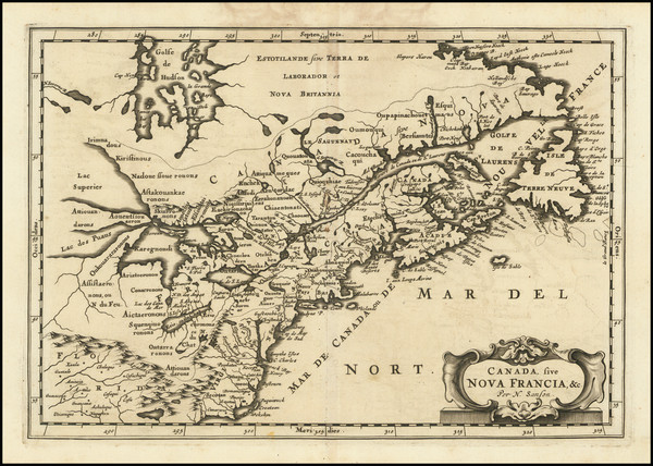
Place/Date:
Amsterdam / 1728
Size:
23 x 20 inches
Condition:
VG+
Stock#:
65061
Place/Date:
London / 1775
Size:
27.5 x 14 inches
Condition:
Stock#:
81949
Place/Date:
Leiden / 1715
Size:
9 x 6 inches
Condition:
VG+
Stock#:
92418
Place/Date:
London / 1747
Size:
17 x 14 inches
Condition:
VG
Stock#:
102804
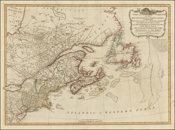
Place/Date:
London / 1755
Size:
24 x 18.5 inches
Condition:
VG
Stock#:
51712
1755 antique Jefferys map showing Eastern Canada.
Place/Date:
London / 1781
Size:
61.4 x 29.5 inches
Condition:
VG
Stock#:
62848
Place/Date:
Frankfurt / 1679
Size:
12 x 8.25 inches
Condition:
VG
Stock#:
97902
Place/Date:
Venice / 1690 circa
Size:
24 x 16 inches
Condition:
VG
Stock#:
0017dg
1690 antique Coronelli map showing Eastern Canada.
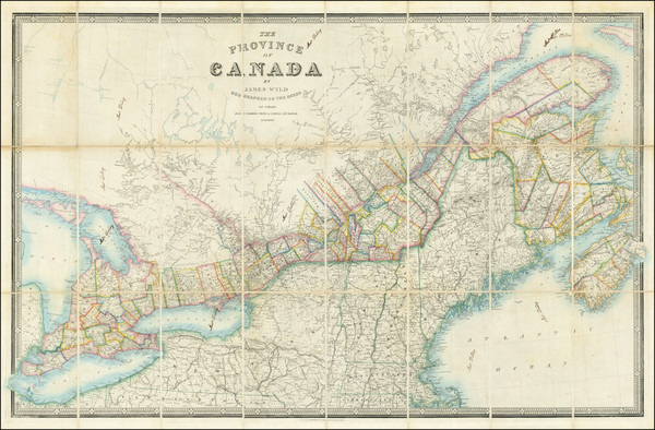
Place/Date:
London / 1856 circa
Size:
37.4 x 23.8 inches
Condition:
VG
Stock#:
85406

Place/Date:
New York / 1857
Size:
51.5 x 37.5 inches
Condition:
Fair
Stock#:
85637
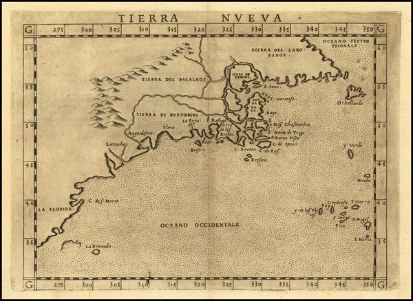
Place/Date:
Venice / 1561 (1574)
Size:
10 x 7.5 inches
Condition:
VG+
Stock#:
86737
Ruscelli's 1561 antique map showing Eastern Canada.
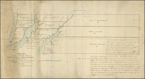
Place/Date:
n.p. (Canada) / 1819 (with later additions)
Size:
27 x 14.5 inches Entire Sheet
Condition:
VG
Stock#:
95012
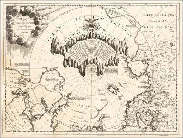
Place/Date:
Amsterdam / 1696 circa
Size:
23 x 18.5 inches
Condition:
VG
Stock#:
47720
Visscher I's 1696 original map showing Eastern Canada.
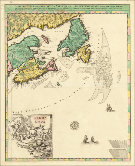
Place/Date:
Paris / 1779
Size:
17.5 x 23.5 inches
Condition:
VG
Stock#:
50750
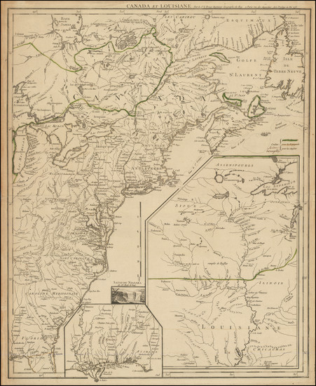
Rare map showing Eastern Canada by Depot de la Marine made in 1779.

Place/Date:
Sweden / 1816
Size:
20.5 x 15 inches
Condition:
VG+
Stock#:
64709
Place/Date:
Louvain / 1597
Size:
11.5 x 9 inches
Condition:
VG
Stock#:
72220
Wytfliet's 1597 original map showing Eastern Canada.
Place/Date:
Philadelphia / 1815
Size:
19.5 x 15 inches
Condition:
Fair
Stock#:
84804
Place/Date:
Amsterdam / 1745
Size:
24 x 21 inches
Condition:
VG
Stock#:
87829
Place/Date:
Amsterdam / 1659
Size:
21 x 17 inches
Condition:
VG+
Stock#:
72826
Place/Date:
Paris / 1740
Size:
12.5 x 9.5 inches
Condition:
VG+
Stock#:
85117mb
Place/Date:
Cologne / 1598
Size:
9 x 7 inches
Condition:
VG+
Stock#:
81756

Place/Date:
n.p. / 1835 circa
Size:
16.5 x 11 inches
Condition:
VG
Stock#:
74238
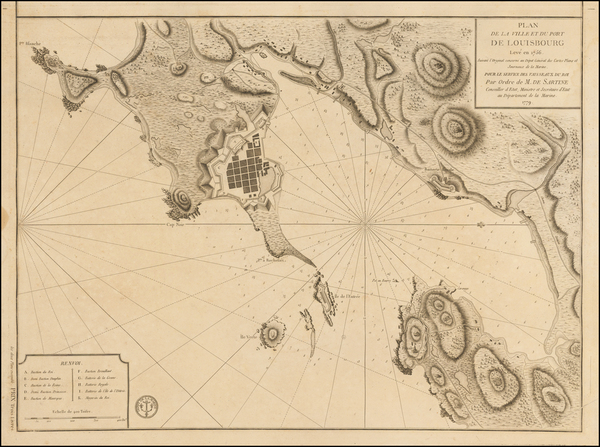
Place/Date:
Paris / 1784
Size:
23.5 x 34.5 inches
Condition:
VG+
Stock#:
97814
Place/Date:
Amsterdam / 1696
Size:
22.5 x 34.5 inches
Condition:
VG
Stock#:
99328
Place/Date:
Amsterdam / 1680
Size:
23.5 x 20 inches
Condition:
VG
Stock#:
79385
Place/Date:
London / 1813
Size:
35 x 23 inches
Condition:
Good
Stock#:
76160
Place/Date:
Paris / 1755
Size:
24 x 20 inches
Condition:
VG
Stock#:
78836
Place/Date:
Amsterdam / 1737
Size:
20.5 x 22 inches
Condition:
Good
Stock#:
64717
Place/Date:
Amsterdam / 1695 circa
Size:
23 x 20 inches
Condition:
VG+
Stock#:
94453
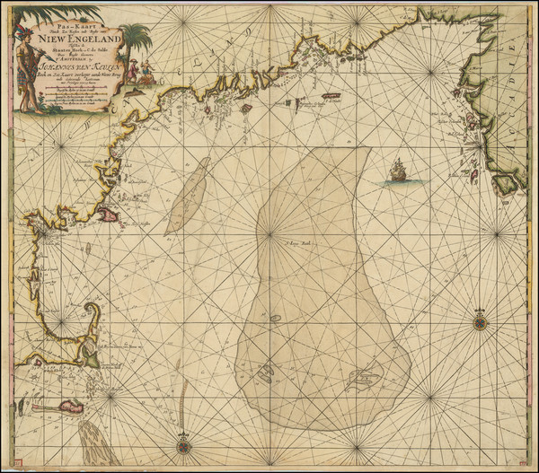
Van Keulen's 1695 antique map showing Eastern Canada.
Place/Date:
Paris / 1755
Size:
19.5 x 24 inches
Condition:
VG
Stock#:
93039
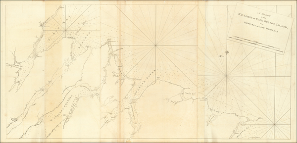
Place/Date:
London / 1777 circa
Size:
31.5 x 24 inches
Condition:
Good
Stock#:
53739
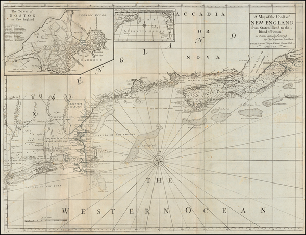
Antique map showing Eastern Canada by Mount & Page / Southack, 1777.
Place/Date:
n.p. / 1856 circa
Size:
40 x 16.4 inches (each sheet)
Condition:
VG
Stock#:
92802
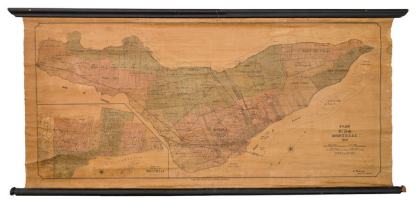
Place/Date:
Montreal / 1890
Size:
44 x 20.5 inches
Condition:
Good
Stock#:
103021
Place/Date:
Paris / 1656
Size:
21 x 15.5 inches
Condition:
VG
Stock#:
99318

Place/Date:
Amsterdam / 1684 circa
Size:
21.5 x 18.5 inches
Condition:
VG
Stock#:
93874
Place/Date:
Paris / 1756
Size:
18.5 x 14.5 inches
Condition:
VG+
Stock#:
103184