
Search
Old and antique maps of Eastern Canada for sale. Our authentic Eastern Canada map inventory features antique maps of Canada from the period of New France, the Hudson Bay Company, and early exploration by mapmakers such as Champlain. Our map inventory typically includes antique and vintage city views and plans of Montreal, Quebec, and Toronto, as well as maps of Ontario, Upper and Lower Canada, Quebec, Newfoundland and Labrador, Prince Edward Island, Nova Scotia, and New Brunswick. Vintage pictorial maps of Eastern Canada are also for sale.
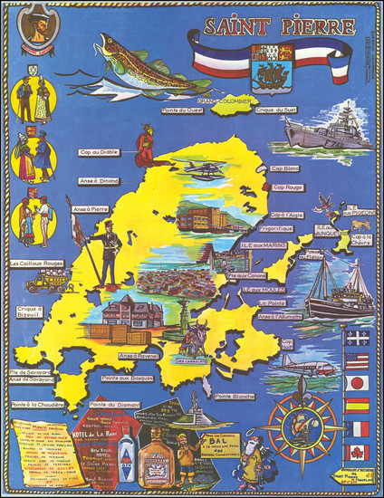
Place/Date:
n.p. / 1967
Size:
18 x 23 inches
Condition:
VG+
Stock#:
82287
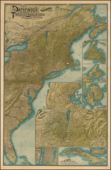
Place/Date:
Boston / 1901
Size:
28 x 42.5 inches
Condition:
Good
Stock#:
87611
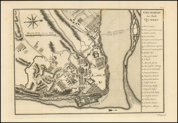
Place/Date:
Paris? / 1758 circa
Size:
11 x 8 inches
Condition:
VG+
Stock#:
95216
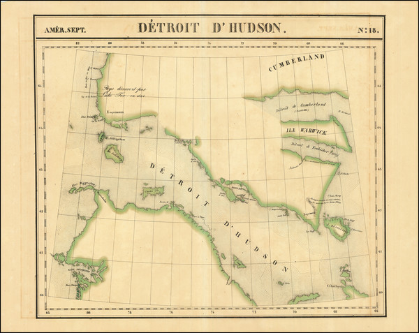
Place/Date:
Brussels / 1825
Size:
22 x 18.5 inches
Condition:
VG
Stock#:
96886
Place/Date:
Paris / 1749
Size:
8 x 7 inches
Condition:
VG
Stock#:
99952
Place/Date:
London / 1807
Size:
20 x 18 inches
Condition:
VG+
Stock#:
100331
Place/Date:
Paris / 1743
Size:
13 x 9.5 inches
Condition:
VG+
Stock#:
49692
Antique map showing Eastern Canada by Buache made in 1743.

Place/Date:
London / 1852 circa
Size:
21.5 x 9 inches
Condition:
VG+
Stock#:
68325
Place/Date:
Paris / 1763
Size:
34 x 22 inches
Condition:
VG
Stock#:
80010
Original map showing Eastern Canada by Depot de la Marine made in 1763.
Place/Date:
Paris / 1683
Size:
4.5 x 6 inches
Condition:
VG+
Stock#:
97657
Mallet's 1683 antique map showing Eastern Canada.
Place/Date:
Paris / 1787
Size:
17 x 11.75 inches
Condition:
VG
Stock#:
98746
Place/Date:
New York / 1838
Size:
13 x 13.5 inches
Condition:
VG+
Stock#:
78205

Place/Date:
New York / 1871
Size:
15.5 x 13 inches
Condition:
VG
Stock#:
79044
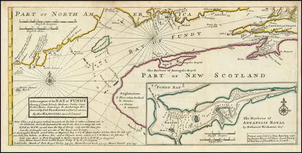
Place/Date:
London / 1708
Size:
10 x 7 inches
Condition:
VG+
Stock#:
79487
Antique map showing Eastern Canada by Moll made in 1708.
Place/Date:
Washington, D.C. / 1874
Size:
10 x 5.5 inches
Condition:
VG+
Stock#:
79556
Place/Date:
Brussels / 1825
Size:
22.5 x 18.5 inches
Condition:
VG
Stock#:
80198
Place/Date:
London / 1758 circa
Size:
7 x 4.5 inches
Condition:
VG
Stock#:
93283
Place/Date:
Hamburg / 1688
Size:
7 x 12 inches Including Text
Condition:
VG
Stock#:
94772
Place/Date:
Paris / 1752
Size:
11 x 9 inches
Condition:
See Description
Stock#:
99758
Bellin's 1752 antique map showing Eastern Canada.
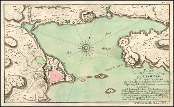
Place/Date:
Nuremberg / 1764 circa
Size:
15 x 9 inches
Condition:
VG+
Stock#:
57909
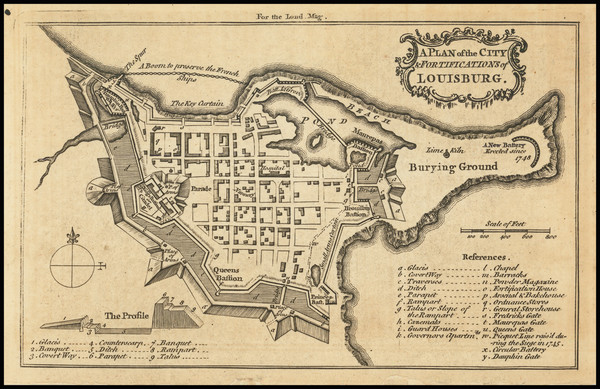
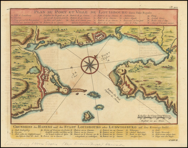
Rare map of Louisbourg

Place/Date:
Montreal / 1875
Size:
23.3 x 14.5 inches
Condition:
Good
Stock#:
70011
Place/Date:
Toronto (?) / 1877 circa
Size:
25.5 x 15.25 inches
Condition:
VG
Stock#:
95879
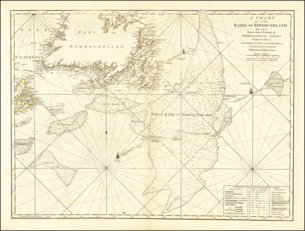
Place/Date:
London / 1775
Size:
26 x 19.5 inches
Condition:
VG
Stock#:
66311
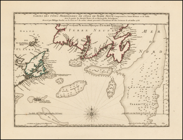
Antique Sea Chart of the Banks of Newfoundland
Place/Date:
London / 1815
Size:
7 x 4.5 inches
Condition:
VG+
Stock#:
86568

Place/Date:
Montreal / 1922
Size:
47 x 40.25 inches Including text
Condition:
VG
Stock#:
87409
Place/Date:
Scarborough, Ontario / 1974
Size:
39.5 x 29.5 inches (sheet size)
Condition:
VG+
Stock#:
95200
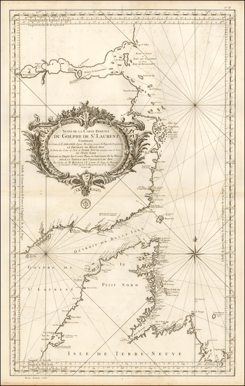
Place/Date:
London / 1775
Size:
19.5 x 24 inches
Condition:
VG
Stock#:
66231
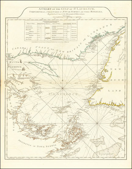
Antique Map of Gulf of St. Laurence
Place/Date:
Edinburgh / 1814
Size:
24 x 16 inches
Condition:
VG+
Stock#:
71643

Place/Date:
Boston / 1796
Size:
9 x 7 inches
Condition:
VG+
Stock#:
75858
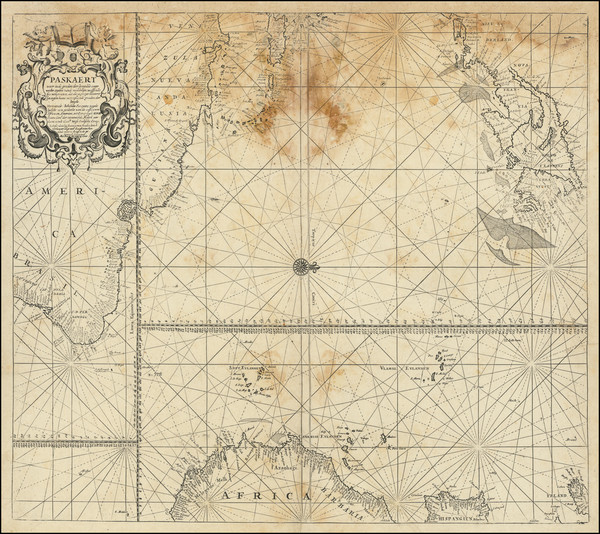
Place/Date:
Amsterdam / 1680
Size:
23.5 x 20 inches
Condition:
Fair
Stock#:
94147
Place/Date:
London / 1729
Size:
17.5 x 8.5 inches
Condition:
VG
Stock#:
94762
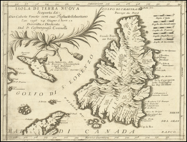
Place/Date:
Venice / 1690 circa
Size:
12 x 9 inches
Condition:
VG
Stock#:
98645
Original map showing Eastern Canada by Coronelli made in 1690.
Place/Date:
Paris / 1753
Size:
35 x 21.5 inches
Condition:
VG
Stock#:
54829
Antique map showing Eastern Canada by Bellin made in 1753.
Place/Date:
Paris / 1778
Size:
22 x 35 inches
Condition:
VG
Stock#:
62923
Place/Date:
London / 1758
Size:
14.5 x 11 inches
Condition:
VG
Stock#:
69378
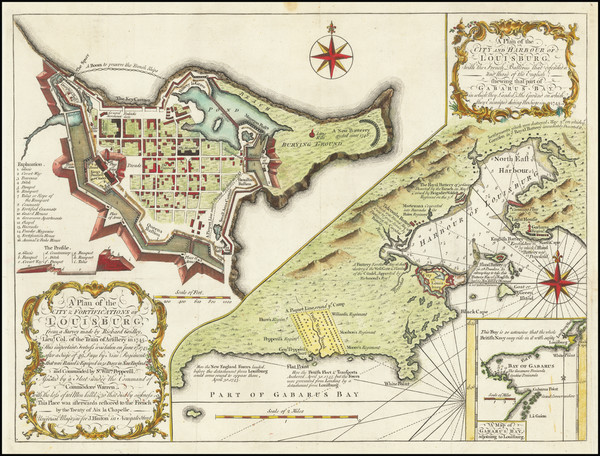
Antique Map of Louisbourg
Place/Date:
London / 1797
Size:
7.5 x 9 inches
Condition:
VG
Stock#:
68039
Place/Date:
Toronto / 1846
Size:
21 x 15 inches
Condition:
Good
Stock#:
94730
Place/Date:
London / 1838
Size:
34 x 23 inches
Condition:
Good
Stock#:
51522
1838 antique Wyld map showing Eastern Canada.
Place/Date:
London / 1746
Size:
18.5 x 13.5 inches
Condition:
VG
Stock#:
55886
Antique map showing Eastern Canada by Gentleman's Magazine, 1746.

Place/Date:
Paris / 1764
Size:
14 x 9 inches
Condition:
VG+
Stock#:
58966
Antique map showing Eastern Canada by Bellin, 1764.
Place/Date:
Boston / 1796
Size:
9 x 7 inches
Condition:
VG
Stock#:
79663

Place/Date:
Edinburgh / 1745
Size:
9.5 x 7 inches
Condition:
VG
Stock#:
79488
Place/Date:
Leipzig / 1756
Size:
22 x 16 inches
Condition:
VG
Stock#:
91082
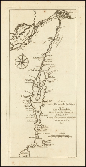
Place/Date:
Paris / 1744
Size:
5.5 x 12 inches
Condition:
VG
Stock#:
91308
Place/Date:
London / 1792
Size:
15.5 x 12.5 inches
Condition:
VG
Stock#:
99856
Place/Date:
Paris / 1765
Size:
34 x 21.5 inches
Condition:
VG+
Stock#:
80022

Place/Date:
Paris / 1761
Size:
33 x 22.5 inches
Condition:
VG+
Stock#:
80008
Place/Date:
Amsterdam / 1765
Size:
17 x 13 inches
Condition:
VG+
Stock#:
93087
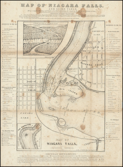
Place/Date:
Buffalo, New York / 1840 circa
Size:
12 x 15 inches
Condition:
Good
Stock#:
94591
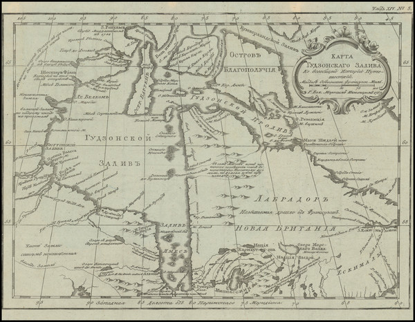
Place/Date:
St. Petersburg / 1760
Size:
12 x 9 inches
Condition:
VG+
Stock#:
100628