This item has been sold, but you can enter your email address to be notified if another example becomes available.


|
||

|

|
|

|
Stock# m0436
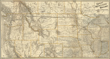
Description
One of the earliest obtainable maps of Iowa, published 4 years after it became a state. Over half the state is not yet delineated by counties and a massive Neutral Ground is shown, reflecting the regions which are still controlled by the Indians. The remainder of the mao is hand colored by counties and shows township surveys, towns, roads, rivers, etc.