This item has been sold, but you can enter your email address to be notified if another example becomes available.


|
||

|

|
|

|
Stock# m0356
Description
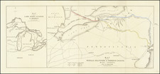
A scarce War of 1812 map of a portion of Lake Ontario and the St. Lawrence River, from James' Full & Correct Account of the Military Occurances of the Late War Between Great Britain and the United States, published in London in 1818. Includes a large inset of Kingston Harbor with town plan and soundings and a large inset of the area around Sacket's Harbor and Fort Tompkins and Fort Pike, showing batteries, roads, a saw mill, hospital, etc. The main map extends west to Stoney Island, Gage Island, Wolfe Island, etc. A scarce map which we have never offered prior to this example.
![[New England] Tierra Nueva](https://storage.googleapis.com/raremaps/img/small/64626.jpg)