


|
||

|

|
|

|
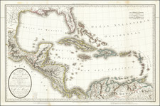
Rare London Printed Spanish Sea Chart
Rare Spanish sea chart of the southern half of the Spanish Main, published in London.
The chart was published in London with a credit to Jose de Espinosa in 1810, based upon an 1808 chart by the Spanish Hydrographical Office and other available sources, with corrections made in 1812. The chart covers the maritime region of the Caribbean Sea, specifically from the mouths of the Orinoco River to the Gulf of Honduras.
Inset maps include:
- Plano de Puerto Cabello en la Costa de Tierra Firme
- Plano de la Ensenada de Barcelona
- Plano del fondeadero de la Guayra
- Plano de la boca del Golfo de Cariaco y del fondeadero de Cumana
The history of this chart is intertwined with a period in the early 19th Century when official Spanish map and chart making was in serious disarray. In 1789, Felipe Bauzá had been charged with creating the charts for Alessandro Malaspina's expedition to the Americas, Oceania and Australasia. The purpose was to accurately map Spanish America, the Philippines, and the islands of the Pacific. Bauzá's mission was to assemble the best available maps and create new maps. The voyage lasted from July 1789 to September 1794. Bauza's maps were published between 1797 and 1807 and became the basis for Spanish maps of the region for the rest of the 19th Century. Bauza was joined on the expedition by Jose de Espinosa y Tello. In August 1797 he was appointed deputy head of the newly founded Dirección de Hidrografia under Espinosa, whom he succeeded in 1815.
During this period, on two occasions during the Napoleonic Wars (1808 and 1810), Bauza and Espinosa y Tello were forced to flee Madrid to Cadiz with the holdings of the Spanish Dirección de Hidrografia, in order to avoid capture. They also were actively collaborating with the English during this period, as part of the Campaign against Napoleon, including supplying Lord Wellington and General Graham with maps. Bauza had dreamed of publishing a complete atlas of his work and by the early 1820s, he had fled Spain and for London with his map collection.
The information for the chart almost certainly derives from the official Spanish expedition led by Alessandro Malaspina between 1789 and 1794, for which Jose Espinosa y Tello and Felipe Bauza both served as chartmakers. First Espinosa y Tello and later Bauza would serve as heads of the Spanish Hydrographical office and, during the Napoleonic War, would collaborate with the English, including the sharing of maps, in opposition to Napoleon's campaigns.
The most likely conduit in London would be the esteemed astronomer and mathematician Josef Mendoza y Rios, who had been resident in the UK for several decades and was closely acquainted with both Spanish Mariners, with whom he had worked in preparation for the Malspina Expedition and in establishing the Spanish Hydrographical Library, before leaving for the UK in the 1790s. Notably, he was also the dedicatee on Aaron Arrowsmith's monumental 9 sheet map of the Pacific.
![Culiacanae, Americae Regionis, Descriptio [with] Hispaniolae, Cubae, Aliarumqe Insualrum Circumiacientium Delineatio](https://storage.googleapis.com/raremaps/img/small/86114.jpg)
![Colton's West Indies [Bermuda and Havana insets]](https://storage.googleapis.com/raremaps/img/small/67374.jpg)