


|
||

|

|
|

|
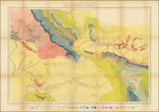
Fine large map of the area around Jackson Lake and the Snake River Valley, published by the United States Geological Survey.
The map extends to Jackson, Wyoming in the south to the area just south of Yellowstone Park, employing detailed contour lines, topographical details and color coding to show different types of Terrain. The map would be re-issued a decade later in a similar size, but with significant graphical stylistic changes.
This is one of the largest maps of the region published by the US Geological Survey, Marked with a magnetic declination for the year 1948, is the product of a joint endeavor by the United States Geological Survey and the United States Coast and Geodetic Survey. The meticulous process of mapping topography was conducted through the use of aerial photographs taken by multiplex methods, complemented by plane-table surveys in the mid-1930s. In July of 1948, these photographs were updated to capture the current state of the landscape, with a rigorous field check following suit to ensure the map's precision.
The map uses a polyconic projection and calibrated to the 1927 North American Datum, the map is structured around a 10,000-foot grid system, tailored to the Wyoming coordinate system for the west zone.
The delineation of roads is exhaustive, classifying them by their construction quality and adaptability to weather conditions, ranging from robust, all-weather, multi-lane thoroughfares to lesser, unimproved dirt tracks. The map further distinguishes the hierarchy of roads, differentiating between federal U.S. Routes and those designated at the state level, thereby providing a comprehensive overview of the transport infrastructure.
![[Montana, Wyoming, Dakota, Upper Missouri River] Amer. Sep. No. 40. Partie des Etats Unis](https://storage.googleapis.com/raremaps/img/small/93546.jpg)
![[Wall Map of Jackson Hole and Environs] Grand Teton National Park Wyoming - Teton Country 1968](https://storage.googleapis.com/raremaps/img/small/99906.jpg)