|
||

|

|
|

|
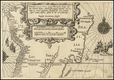
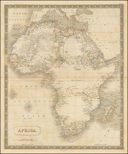
A handsome example of this rare two-sheet sea chart of the Coasts of Brazil, West Africa, and South Africa, published by Johannes Van Keulen (the younger) around 1726. According to de Vries, Schilder, Bruyns, van Iterson, and Jacobs, in The Van Keulen Cartography, the chart was first published separately around 1726 and subsequently began appearing in atlases in 1728. It was printed until about 1755.
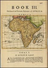
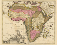
The chart depicts the western coast of Africa and the South American coast of Brazil, along with parts of Guyana. It stretches from Cape Verde in the north of Africa down to the Cape of Good Hope in the south, and from Rio de Berbice to Rio de la Plata in South America. While it provides detailed information along the coasts, particularly notable is its expansive coverage of inland territories in Africa. There, it shows much in the way of interior hydrography and intricate political divisions unlike many similar sea charts of this era.
The Chart's Dedication and the Dutch West India Company
On the left side of the chart, in the interior of Brazil, is a large dedicatory cartouche to Abraham Anias, with the signature of Johannes van Keulen.
Abraham Anias (1694 – 1750) was a cartographer for the Dutch East India Company (VOC) and the stepson of Jacob Roggeveen (1659-1729), a significant cartographer from Middelburg. Anias served as the inspector of weights and measures (ijkmeester) for the Zeeland Chamber of the Dutch West India Company (WIC) from 1720 to 1750. In his role, he was responsible for examining helmsmen (stuurlieden). His expertise and skills in this position earned him a significant reputation among his professional colleagues.
The chart was relevant for the activities of both the WIC and the VOC during this period. For the Dutch East India Company, the chart covers an important section of the route to the East Indies, including the famous Waagen Weg ("Wagon Road") just above the equator.
For the Dutch West India Company, this chart covered a significant portion of the slave trade route between West Africa and the South American and Caribbean plantations where the WIC conducted most of its business. The map includes an elaborate listing of placenames along the coast of West Africa, including the primary slave ports. In the west, it extends to Fort Zeelandia (Paramaribo, Suriname) and farther west to Forts N. Zeelandia and N. Middelburg. This coast, along with Caribbean islands such as Curaçao, was the primary endpoint for WIC slave traders.
The Van Keulens were a family of chartmakers and publishers. The firm, In de Gekroonde Lootsman (In the Crowned Pilot), was founded in 1678 by Johannes van Keulen (1654-1715). Van Keulen originally registered his business as a vendor of books and instruments (specifically cross-staffs). In 1680, however, he gained a privilege from the States of Holland and West Friesland for the publication of pilot guides and sea atlases.
In that year, van Keulen released his Zee-Atlas (Sea Atlas), which secured him a name in the competitive maritime publishing market. In 1681, he published the first volume of Nieuwe Lichtende Zee-Fakkel (New Shining Sea Torch). This would be the first of an eventual five volumes originally published between 1680 and 1684. A sixth volume was added in 1753. The Zee-Fakel won van Keulen lasting fame. The atlas had charts compiled by Claes Jansz Vooght and artwork from Jan Luyken. It proved immensely popular and was reprinted until 1783. There were translations in French, English, Spanish, and Italian.
The late-seventeenth century was an auspicious time to enter the maritime chart business. Previous industry leaders had either closed shop, died, or retired, leaving space for a new competitor. Van Keulen proceeded to buy up the stock and privileges of several maritime publishing firms; the most notable was the stock of Hendrik Doncker, acquired in 1693.
Johannes’ son, Gerard (1678-1726) took over the business upon his father’s death. Gerard was a skilled engraver and mathematician. His talents were noticed, as in 1706 he was named as Hydrographer to the Dutch East India Company (VOC).
In turn, Gerard’s son Johannes II (1704-1770) came to run the shop. He was also tied to the VOC, and his role as their chartmaker allowed his charts to be considered as quasi-official government documents. It is with access to formerly clandestine VOC geographic knowledge that Johannes the Younger was able to add a sixth volume to the Zee-Fakkel, which covered the East Indies. Johannes also continued to sell instruments, including the recently-invented Hadley’s Quadrant from 1744.
When Johannes II died in 1770, his widow ran the business in his stead, aided by her two sons, Cornelis Buys (1736-1778) and Gerard Hulst (1733-1801). Now a century old, the family business had extended to include an anchor factory. After Cornelis died in 1778, Gerard took on the management of the firm alone. He oversaw the introduction of sextants to their inventory and published the Dutch Nautical Almanac beginning in 1788. Annual editions appeared until 1885. Gerard also served as an original member of the Dutch Commission for Longitude at Sea from 1787.
Gerard’s widow ran the business for nine years after his death, when their son, Johannes Hulst, started to lead the firm in 1810. After his death in 1844, the firm passed out of family hands and into the control of Jacob Swert, a skilled cartographer who had worked for the business for two decades. He passed the work to his son, another Jacob, in 1866. By the mid-nineteenth century, the conversion from sail to steam had diminished the size of the market for charts. Fewer sailors needed fewer maps, charts, and instruments. In 1885, after 207 years in business, In de Gekroonde Lootsman closed its doors and auctioned its stock.