


|
||

|

|
|

|
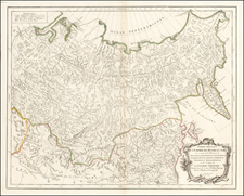
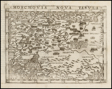
This 1784 map, created by Tobias Conrad Lotter in Augsburg, reflects the comprehensive geographical understanding of the Russian Empire in the late 18th century, based on the pioneering survey by Johann Treskot and Johann Schmidt. It represents a significant stride in the accurate and detailed mapping of Russia, encompassing regions from Lithuania and Poland to the Pacific Ocean and the Aleutian Islands.
This map is based upon the work of Johann Treskot and Johann Schmidt, whose 23-sheet survey of Russia, completed in 1775 or '76 for the Imperial Academy of Sciences.
From Lithuania and Poland in the west to the Pacific Ocean and the Aleutian Islands in the east, the Russian Empire sprawls across this map with great detail and refinement.
Treskot & Schmidt's survey of Russia was the next major survey following the work of Joseph Nicolas De L'Isle. Almost immediately after the publication of De l'Isle's atlas of Russia in 1745, the Geographical Department of the St. Petersburg Academy of Sciences began planning for a new atlas of Russia. For various reasons, however, an updated work would not appear for several decades. As noted by Leo Bagrow
There are frequent references to atlases of the Russian Empire published during the decades of the 1750's and 1760's…Actually, these atlases were simply loose collections of maps published the years following 1754, primarily during the period of Lomonosov and Rumovskiy…Copies of such atlases were individual collections of maps, sometimes provided with a title page which, it would seem, was usually printed in one copy only.
The most prolific of these mapmakers were Johann Schmidt and Johann Treskot. Bagrow notes that these mapmakers were actively revising De L'Isle's work in the 1750s and 1760s, with Schmidt focused on the Baltic Regions and Treskot on Siberia.
The present map is based upon a 3-sheet map of similar size, engraved in St. Petersburg by K. Frolov, E. Khudiakov, and N. Zubkov in 1776.
Tobias Conrad Lotter (1717-1777) is one of the best-known German mapmakers of the eighteenth century. He engraved many of the maps published by Matthaus Seutter, to whose daughter Lotter was married. He took over Seutter’s business in 1756. Lotter’s son, M. A. Lotter, succeeded his father in the business.
![[ Tsar Alexander II ] Alexander II Kaiser von Russland](https://storage.googleapis.com/raremaps/img/small/91242.jpg)