|
||

|

|
|

|
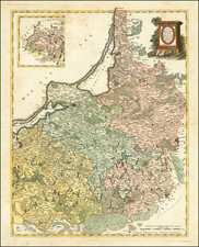
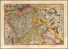
Crepy;s "Le Royaume de Prusse," published in Paris in 1757, portrays the Kingdom of Prussia at a time when it was a burgeoning European power.
The map delineates the boundaries of Prussia, showcasing its provinces with a fine network of cities, towns, and the sinuous courses of rivers, all rendered with the cartographic precision typical of the era.
The year 1757 situates this map in the midst of the Seven Years' War, a global conflict that saw Prussia, led by Frederick the Great, contesting the might of Austria, Russia, France, and Sweden for supremacy in Central Europe. Prussia's strategic geographical position as depicted on the map, with the Baltic Sea to the north and the intricate patchwork of German states to the west and south, reveals the complex geopolitical chessboard on which Frederick the Great played. It was a period marked by military campaigns, shifting alliances, and territorial disputes that shaped the nature of European politics.
The map indicates the extent of Prussian territory just before its apex, highlighting the areas that Frederick the Great would defend and extend through his military endeavors. The detailed depiction of the realm's topography and political demarcations offers insights into the logistical challenges and strategic considerations of 18th-century warfare. The Kingdom of Prussia, at this point in history, was on the cusp of ascending to the ranks of the great powers of Europe, an ascent that would be significantly influenced by the outcomes of the conflicts represented in the intervals between the neatly inked lines of this map.
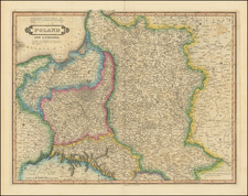
The map significant implications for Poland and Lithuania. This period is characterized by the complex and often contentious relationship between these nations, particularly in the context of the evolving political and military landscapes of Eastern Europe. During the mid-18th century, the Polish-Lithuanian Commonwealth was experiencing a period of internal decline and external pressure. The elective monarchy was weakened by the liberum veto, which allowed any member of the Sejm (parliament) to end the current session and nullify any legislation that had been passed. This political system led to paralysis and a gradual erosion of central authority, leaving Poland-Lithuanian vulnerable to the ambitions of its neighbors.
The map illustrates Prussia's geopolitical ascendance under Frederick the Great, whose ambitions brought him into direct conflict with the Commonwealth. The Kingdom of Prussia's territorial ambitions were realized in part at the expense of the Polish-Lithuanian Commonwealth, which was partitioned at the end of the century, with Prussia annexing significant portions of Polish territory.
Furthermore, the Seven Years' War, contemporaneous with the map's publication, had a destabilizing effect on Poland-Lithuania. While not a belligerent, the Commonwealth's territory served as a battleground for the conflict's major powers, further undermining its sovereignty and laying the groundwork for the partitions.
![[Estonia / Latvia] La Livonie Avec les frontieres de Courlande et de Finlande](https://storage.googleapis.com/raremaps/img/small/88602.jpg)