


|
||

|

|
|

|
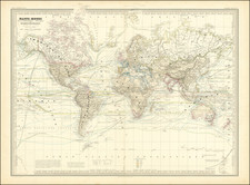
The Telegraphic World 12 Years After The First Successful Wired Cable
Detailed map of the World, illustrating the modern lines of communication throughout the World, including Telegraph lines, steamships, railroads, etc.
This 1878 Planisphère Terrestre offers a comprehensive visualization of the global network of telegraph cables, railways, and steamship routes, underpinning the era’s industrial expansion and colonial endeavors. Lithographed by A. Logerot, the map illustrates the technological advancements that were shrinking the world and redefining human interaction on a global scale.
The map offers a detailed overview, including dates of the laying of the web of telegraphic communication --Télégraphie Électrique—to become the nervous system of international commerce and diplomacy, enabling messages to traverse oceans and continents with unprecedented speed.
The map's detailed depictions of steamship routes mirror the arteries of global trade and movement. The rise of the steamship, or paquebot, revolutionized sea travel, accelerating the exchange of goods and people across the seas.
In the context of telegraphy, the map delineates the sprawling network of submarine cables laid by visionary entrepreneurs and empires eager to harness the power of instantaneous communication. By the time of publication of this map, transatlantic cables had become the technological marvels of their time, with the first successful transmissions in 1866 igniting a race to wire the world.
![[ Original Artwork ] Carriers of the New Black Plague](https://storage.googleapis.com/raremaps/img/small/101825.jpg)